Showing posts with label Canada. Show all posts

Tuesday, 2 March 2021

Yellow Dog Lodge - Duncan and Graham Lakes, Northwest Territories


You would be imagining this: a fly-in fishing adventure with wilderness solitude, pristine waters, and trophy-size lake trout and northern pike to complete a too-good-to-be-true scenario. Unfortunately, the not-so-dreamy component of a fishing holiday at the remote northern lake has often been the lodge itself—sometimes no more than a set of weather-beaten cabins that puts the rough back in roughing it. However, a new generation of Canadian fishing lodges is set to prove that you don’t need to give up on comfort and fine food as you fish the lakes of the little-visited Northwest Territories.

Just 20 minutes north by floatplane from Yellowknife, the territorial capital, Yellow Dog Lodge is an exemplar of this new breed of backcountry destinations. On Pilot Point, which sits on a rocky divide between Duncan and Graham Lakes, Yellow Dog seamlessly blends the features of a high-toned ecotourism resort and a traditional fishing camp. During the long summer days, guided day hikes take guests past mossy bogs, across trickling ponds, and through the taiga, the boreal forest of spruce and fir that covers the rocky barrens.

From canoes and kayaks, guests can explore the lakeshore and view wildlife—moose, beaver, and nesting waterfowl all make a home in this aqueous landscape. In winter, when the lodge will open on special request, the frozen lakes become highways for snowmobiles, and the silent snow-filled forests invite exploration with snowshoes and Nordic skis. With zero light pollution, the pulsing, multicolored aurora borealis puts on a fantastic display in the fall and winter sky. But fishing remains the focus at Yellow Dog Lodge. Fishing guides will help ensure even amateurs a chance to catch that big one in the deep, pure crystal-clear waters of glacier-trenched Duncan Lake.

There’s also seasonal fly-fishing for Arctic grayling, a colorful trout relative with an outsize dorsal fin that gives a good, hard fight with lots of high, twisting jumps. The comforts of Yellow Dog Lodge are the reward for a long recreation-filled day in the arctic backcountry. Perched above the lake on a rocky outcrop, the lodge provides snug guest rooms, while private chalets extend along a pristine waterfront. The lodge’s food is a point of pride and expression of passion. Owners Kathy and Gordon Gin are excellent hosts and fine cooks, and lodge meals—served family-style in the cozy dining room or, in warm weather, on the lakeside patio—are jubilant occasions that combine great food and convivial conversation.

The wood-fired hot tub offers anglers and hikers a chance to relax weary muscles before another perfect day of adventure in the Canadian Arctic. Where: 30 miles/48 km north of Yellowknife. Tel 403-668-9936; yellow do lodge, double occupancy, includes all meals, lodging, use of equipment, and round-trip transportation from Yellowknife. When: closed Oct-May. Best times: Jan–Apr for winter sports; June–late Sept for fishing; Oct-Mar for northern lights.

Read More - Pallay Punchu – A New Enchanting Beauty in Cusco


Thursday, 23 July 2020

Mount Thor, Canada

Mount Thor is a mountain with an elevation of 5,495 ft located in Auyuittuq National Park, on Baffin Island, Nunavut, Canada. Mt Thor is located 46 kilometers northeast of Pangnirtung. Mount Thor consists of granite and features Earth's greatest vertical drop of 4,101 ft, with the cliff overhanging at an average angle of 15 degrees from vertical. Regardless of its consistency of remoteness, the mountain is a popular rock climbing site. Mt Thor is one of the great unexplored wildernesses, as only very few have conquered it.

Every year, climbers turn their head to this great vertical drop. They do the camping there through designated campsites located throughout the length of Akshayuk Pass. Climbers looking to scale Mt Thor, hence an established campsite just a few kilometers north of its base, complete with windbreaks and emergency shelters.

The mountain was named for Thor, the Norse thunder. Mt Thor is part of the Baffin Mountains which in turn form part of the Arctic Cordillera mountain range. It is also known as the land that never melts. Auyittuq is full of dramatic fjords and majestic peaks like Mount Asgard and Mount Thor.

Mt Thor, west side is the longest vertical drop on Earth, is about 4,101 feet straight down. Therefore, the slope is steeper than vertical, since the face is actually a 105-degree overhang. This mountain is not for a picnic place, it is no serious joke when it comes to climbing attempt. The climbing attempt took place for more than a month. Near the Mt Thor, multiple other activities are available, like paragliding, and parachuting of Thor’s tremendous height. The best time to climb Mt Thor is in August.

First Ascent

In 1965, Lyman Spitzer and Donald Morton made the first ascent of Mt Thor during an expedition led by Pat Baird. However from the Wes side the first ascent made by John Bagley, Earl Redfern, Eric Brand, and Tom Bepler in 1985. The climbing team faced uncontrollably dangers from falling rocks to declining supplies. Although they brought over half a ton of food, gear, and fuel up the cliff with them. The dangerous ascent took them 33 days! In 1998 the first solo ascent to Mount Thor made by Jason Smith.  

The Tallest Near-Vertical Drop on Earth

If you’ve conquered the Mount Thor, then you are looking for new challenges. Hence, you have to head to Gilgit-Baltistan in northern Pakistan. The Great Trango Tower (20,623) is the world’s tallest near-vertical cliff 300 feet taller. In 1984 the first expedition to scale Trango Towers east faces a cartographic incident when he died on the descent. 

The Trango Towers widely considered being the world’s hardest big-wall climb. Every year many expeditions take place from all over the world to visit The Karakoram located north of Baltoro Glacier. All of the routes are highly technical climbs. Overall, the Trango Towers is the combination of altitude, the total height of the routes, and the steepness of the rock is the most challenging rock climbing. 

Mt Thor is one of the great unexplored wildernesses, as only very few have conquered it.

Mt Thor is one of the great unexplored wildernesses, as only very few have conquered it.

Mt Thor is one of the great unexplored wildernesses, as only very few have conquered it.

Mt Thor is one of the great unexplored wildernesses, as only very few have conquered it.

Mt Thor is one of the great unexplored wildernesses, as only very few have conquered it.

Mt Thor is one of the great unexplored wildernesses, as only very few have conquered it.

Mt Thor is one of the great unexplored wildernesses, as only very few have conquered it.

Mt Thor is one of the great unexplored wildernesses, as only very few have conquered it.

Mt Thor is one of the great unexplored wildernesses, as only very few have conquered it.

Product You May Interested

Saturday, 9 May 2020

The Mysterious Crooked Bush of Saskatchewan

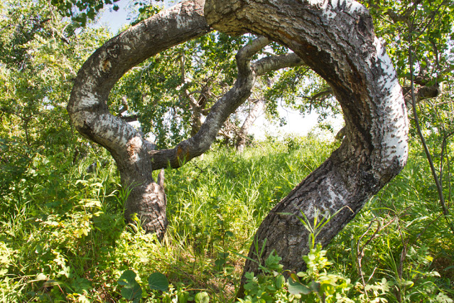
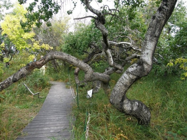
The Crooked Bush, Crooked Trees, or Twisted Trees and the Crooked Trees of Alticane are a grove of deformed trembling aspen trees of type Populus tremuloides Michx in Saskatchewan, Canada. They are usually reaching this height after 15 years. Crooked Bush is found approximately 20 km north-north-west of the town of Hafford, Saskatchewan and 5 km south-west of Alticane. These trees are noticeably different from the un-twisted aspens just across the road.

Therefore, explanations have been offered which include a variety of paranormal factors. Though, cuttings from these trees, exhibit the same pattern of twisted growth, signifying that the cause is rooted in genetics, possibly the result of a mutation. Thus, the trees' strange appearance was observed in the 1940s and attracted the tourists for many decades. However, the proliferation of websites and blogs that mention them gives a lot of hype.

A wooden walkway was constructed through the grove to keep visitors from trampling any new growth. Since the deformity is probable genetic and aspens spread by root suckers, it is likely that all the crooked trees in the grove are clones that originated from a single mutated tree. The grove is at present bounded on all sides by the grid road and a perimeter access road, so the size of the grove is static and is unlikely to continue spreading.

The grove can be seen in the Disney's true-life adventure-fantasy film Perri in 1957. This area is considered as a natural treasure, so be in limits and don’t climb the trees, break branches, litter, or leave the boardwalk. This will support and ensure that the area remains intact for years to come. The average height of crooked trees is 15 to 20 ft and 75 years old.  

Different theories are popular about how it came to be. Some legends believe there is something in the soil, some contaminants that came when a meteorite crashed into the area. However, some believe it was a lightning strike.

What is truly fascinating is the fact that the trees are growing at a normal rate. Their branches are just growing in every direction other than straight up. While the trail is rather short, it features a wooden boardwalk and is an awesome destination for people of all ages and abilities. Summer is a perfect time to visit as new leaves are sprouting.

A picnic bench is installed there to relish the foods and there is no hiking location. There are different kinds of bird species to live in that area offers you relaxing nature music. Rick Simmonds, the owners of this property, upon which the crooked cluster of trees sit, this place is visited more than five thousand visitors each year, and numbers are growing every year. So, it is very imperative for people to understand and realize the uniqueness of this area to preserve and there isn’t another bush like this,

Crooked Bush, Crooked Trees Alticane are a grove of deformed trembling aspen trees of type Populus tremuloides Michx in Saskatchewan, Canada.

Crooked Bush, Crooked Trees Alticane are a grove of deformed trembling aspen trees of type Populus tremuloides Michx in Saskatchewan, Canada.

Crooked Bush, Crooked Trees Alticane are a grove of deformed trembling aspen trees of type Populus tremuloides Michx in Saskatchewan, Canada.

Crooked Bush, Crooked Trees Alticane are a grove of deformed trembling aspen trees of type Populus tremuloides Michx in Saskatchewan, Canada.

Crooked Bush, Crooked Trees Alticane are a grove of deformed trembling aspen trees of type Populus tremuloides Michx in Saskatchewan, Canada.

Crooked Bush, Crooked Trees Alticane are a grove of deformed trembling aspen trees of type Populus tremuloides Michx in Saskatchewan, Canada.

Crooked Bush, Crooked Trees Alticane are a grove of deformed trembling aspen trees of type Populus tremuloides Michx in Saskatchewan, Canada.

Crooked Bush, Crooked Trees Alticane are a grove of deformed trembling aspen trees of type Populus tremuloides Michx in Saskatchewan, Canada.

Crooked Bush, Crooked Trees Alticane are a grove of deformed trembling aspen trees of type Populus tremuloides Michx in Saskatchewan, Canada.

Crooked Bush, Crooked Trees Alticane are a grove of deformed trembling aspen trees of type Populus tremuloides Michx in Saskatchewan, Canada.

Product You May Interested

Tuesday, 18 July 2017

Bouctouche Dune | La dune de Bouctouche, Canada


Bouctouche is a Canadian town, located at the mouth of the Bouctouche River on the coast of the Northumberland, Canada. The Bouctouche Dune or Sandbar is connected to the mainland at a point approximately 3 ½ miles north of Pointe à Jérôme and ranges southeast for over seven miles, providing protection for the waters of Buctouche Bay. The sandbar lies about a mile off of Saint-Thomas-de-Kent, near where the Point Dixon Range Lights were established in 1881 to support vessels in finding the entrance to the bay. Well maintained saltwater beach, frontage is an ideal location for enjoying nature and a focal point for ecotourism. Visitors to this area of the New Brunswick coast will find a memorable tourism experience in a unique natural environment.

Therefore, a footbridge built on the abutments of the old railroad bridge attaches Le Pays de la Sagouine and Rotary Park from the opposite side of the Bouctouche River. Nowadays, the dune can be shared by people who want to relish its singular beauty. The boardwalk is wheelchair, accessible with ramps to the beach and inner bay, and as such, this earth-cache is wheelchair friendly. La dune de Bouctouche was established by J. D. Irving, Limited to keep and restore the significant sand dune that provides habitat for many shorebirds and other migratory birds. A two-kilometer-long boardwalk lets visitors to feel the sense of flora and fauna found on the dune without impacting the subtle ecosystem. The beach is located on the site of the Irving Eco-centre, la Dune de Bouctouche, where a team of interpreters delivers programs and presentations throughout the season to make this coastal habitat known to as many people as possible.
Moreover, a lighthouse on the southern extremity of Buctouche sand bar was put in operation in 1902. The lighthouse is a square wooden building, prevailed by a square wooden lantern rising from the middle of the cottage roof. Thus, the building and lantern are painted white. The lighthouse is 35 feet high from its base to the ventilator on the lantern, and is located on land 4 feet above high water mark. The light is fixed white dioptric, elevated 38 feet above high water mark, and noticeable 11 miles from all points of approach by water. The work was done by Mr. G.W. Palmer, of Kars, whose contract price for the building was $1,289.In 1907, 375 feet of close pilework was put in place to protect the lighthouse from the encroaching sea, and the following year roughly 400 more feet of pipework were added and the boathouse was moved back to a safer position. Source: CP


Wednesday, 10 May 2017

Canada’s Smoking Hills

The smoking hills are well believed to have been burning for centuries, and will do so for many years to come. Most people perceive the Arctic as a clean, pristine environment, but the Smoking Hills, located 350 km east of the Mackenzie Delta, are a natural source of air pollution.  In 1850, British Captain Robert McClure was sent on an expedition aboard the Investigator to the Arctic to pursuit for the lost expedition of Sir John Franklin who had departed England 5 years earlier. It was the second exploration party who went searching for the 129-crew Arctic exploration team, and one of several dozens that were to follow for the next four decades.

Therefore, the Investigator sailed north through the Pacific and entered the Arctic Ocean by way of Bering Strait, sailing eastward past Point Barrow, Alaska to in due course link up with another British expedition from the north-west. When McClure’s exploration party reached the mouth of the river Horton on Beaufort Sea near Cape Bathurst in Canada's Northwest Territories, he observed smoke in the distance. He is suspecting the smokes could be coming from campfires, maybe from Franklin, McClure at once sent a search party to investigate. The party found not flames from Franklin's campfires, but thick columns of smoke emerging from vents in the ground. The sailors get back with a sample of the smoldering rock, and set it down on McClure's desk it burned a hole in the wood.

He thought that rocks to be volcanic, but the fact was something else. The mountains contains actually a large deposits of sulphur-rich lignite (brown coal) which ignite instinctively when the hills erode and the mineral veins are exposed to the air. The fumes they give off comprise sulphur dioxide, sulphuric acid and steam, all of which has acidified the surrounding shallow pools making a pocket of distinguishing acidic biota, in contrast to the typically Arctic biota in adjacent alkaline ponds. Though the soil of the region contains much limestone, the buffer effect has totally disappeared. The adjacent community, “Paulatuk or traditionally spelt Place of Coal”, which is about 105 km east, is named in recognition of the coal found in the area. Source: Charismaticplanet.com


Friday, 27 May 2016

The Magical Spotted Lake, Canada


Spotted Lake is a saline endorheic alkali lake draws countless visitors from around the world located near the city of Osoyoos in British Columbia Canada. The Lake has rich of minerals such as magnesium sulfate, calcium and sodium sulphate and contains extremely high concentrations of minerals such as silver and titanium. In summer, Lake Water evaporates leaving behind colorful mineral deposits. The ameoba-shaped Spotted Lake, changes colors throughout the year and during the summer time divides itself into white, green, blue and yellow pools. It is said that the lake has the highest natural concentration of this mineral in the world. 

The colorful large spots appears according to mineral composition, Magnesium sulfate normally crystallizes in summer play a major role to spot color and remaining minerals in the lake harden to form natural walkways around and between the spots.  Nowadays, the spotted lake is surrounded by a fence to keep people off, but you can get a good view of it from the highway.

These minerals were used in the manufacture of ammunition during First World War. Chinese labour force skimmed up ton a day of salts from Lake Surface and shipped them to munitions vendors in eastern Canada. Later on, the site came under the control of the Ernest Smith Family for a term of about 40 years. The Ernest Smith attempted to create interest in a spa at the lake in 1979. 

Spotted Lake is a strange and significantly important site having great potential of commercial exploitation presently hype much controversy. The native peoples used the lake mud and water for the treatment of aches and ailments. Therefore, officially, Spotted Lake is on private land and therefore theoretically not accessible for close up observation. It is actually recognized to the First Nations of the Okanagan Valley as Kliluk. The spotted lake is surrounded by cairns rock piles often indicating graves. You cannot miss this historic landmark as you drive along the highway just west of the city. A lot of people stop on the side of the road for a longer look.