Showing posts with label Australia. Show all posts

Saturday, 10 June 2023

The Wallaman Falls, Australia

Welcome to an awe-inspiring journey through the natural beauty of Australia! You should explore Wallaman Falls, an extraordinary waterfall that stands tall as one of the country's most captivating landmarks. Prepare to be mesmerized by its grandeur, enchanting surroundings, and fascinating geological features.

Discovering Wallaman Falls

Nestled within the stunning UNESCO World Heritage-listed Wet Tropics rainforest in Queensland, Australia, Wallaman Falls is an iconic destination that leaves visitors in awe. With a total height of 268 meters (879 feet), it proudly claims the title of the country's tallest single-drop waterfall. It's immense beauty and remarkable geological significance make it a must-visit for nature enthusiasts and adventurers alike.

Geological Marvel: The Creation of Wallaman Falls

To truly appreciate Wallaman Falls, it is essential to understand its geological origins. The falls were formed through the powerful forces of erosion and water flow over millions of years. The cascade is situated along Stony Creek, which meanders through an ancient volcanic basalt lava flow. This unique geological makeup, combined with the surrounding rainforest's rich biodiversity, creates a captivating landscape that appeals to both scientists and nature lovers.

A Symphony of Natural Wonders

1. Majestic Plunge Pool

At the base of Wallaman Falls lies a magnificent plunge pool, fed by the cascading waters. The pool serves as a tranquil oasis, providing a refreshing respite for those seeking relief from the tropical heat. Visitors can bask in the soothing ambiance while marveling at the falls' uninterrupted flow, creating a symphony of sights and sounds.

2. Lush Rainforest Wonderland

Wallaman Falls is enveloped by the enchanting Wet Tropics rainforest, one of the oldest and most diverse rainforests on Earth. Its emerald canopy shelters an astounding array of flora and fauna, making it a haven for nature enthusiasts. Wander along the well-maintained walking trails, and you'll be rewarded with encounters with unique plant species, vibrant birdlife, and, if you're lucky, glimpses of curious marsupials like the Lumholtz's tree-kangaroo.

3. Geological Splendor: Basalt Columns

Adding to the falls' allure are the striking basalt columns that flank its sides. These hexagonal rock formations, reminiscent of towering organ pipes, are a testament to the geological processes that shaped the landscape. Marvel at the symmetrical beauty of these columns, a natural masterpiece that further enhances the grandeur of Wallaman Falls.

Wallaman Falls: A Thrilling Adventure

For adventure seekers, Wallaman Falls offers an array of activities to get your adrenaline pumping. Embark on an exhilarating hiking expedition, trekking through the rainforest and ascending to vantage points that provide breathtaking panoramic views of the falls. Capture the perfect photograph or simply soak in the awe-inspiring scenery as you immerse yourself in nature's embrace.

Preserving the Pristine Beauty

The preservation of Wallaman Falls and its surrounding ecosystem is of utmost importance. Efforts have been made to ensure its protection, including the implementation of sustainable tourism practices, educational initiatives, and ongoing research. By visiting Wallaman Falls, you not only witness its majesty firsthand but also contribute to the conservation efforts that safeguard this natural wonder for future generations.

Plan Your Visit

To make the most of your visit to Wallaman Falls, consider the following tips:

  • Getting There: The falls are located within Girringun National Park, approximately 50 kilometers (31 miles) west of Ingham. Accessible by road, a well-maintained car park is available near the falls' lookout.

  • Best Time to Visit: Wallaman Falls is a year-round destination, but the wet season (December to March) showcases the falls in their full glory. However, be aware that heavy rainfall can affect accessibility during this period.

  • Safety: While exploring Wallaman Falls, prioritize your safety by adhering to signage, staying on designated paths, and avoiding prohibited areas. It's essential to exercise caution, especially near cliff edges and slippery surfaces.

Conclusion

Wallaman Falls stands as a testament to the captivating beauty and geological marvels that Australia has to offer. Its towering cascade, nestled within the lush embrace of the Wet Tropics rainforest, provides an unforgettable experience for those fortunate enough to witness its grandeur. By venturing to this extraordinary destination, you'll embark on a journey that combines adventure, tranquility, and an appreciation for the intricate wonders of our natural world.


Wednesday, 13 May 2020

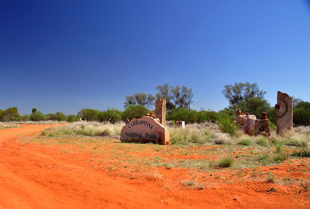
Currawinya National Park, Queensland, Australia

Two vast lakes — Wyara and Numalla — are the centerpiece of 154,870 ha Currawinya National Park, but they are not the only reasons to visit. Currawinya is rich in nature and cultural heritage. Visitors can bird watch, fish, or enjoy the solitude of camping beside the Paroo River.

Access

Near Hungerford on the Queensland/New South Wales border, all access roads to Currawinya are unsealed and impassable when wet. A 4WD vehicle is recommended.
From Cunnamulla, drive 70 km south-west to Eulo, then a further 4 km west before turning south towards Hungerford. The final 97 km to the park office takes 1 to 1.5 hours to drive.
From the south, enter the park via Hungerford, 217 km north-west of Bourke. The park office is 20 km north of Hungerford. Access is via working pastoral properties. Take care to avoid stock on unfenced roads and leave gates as you find them.
Hence, respect the rights of property owners. After good rains (either locally or far upstream) flooding isolates the park for long periods and can submerge campsites along the Paroo River. Therefore, you need to check conditions before traveling and always carry extra supplies in case of stranding. The nearest fuel and supplies are located at Cunnamulla and Thargomindah.

Camping

Bush camp at Ourimperee Waterhole is behind the Woolshed (close to flushing toilets and a bush shower), or at sites on the Paroo River near Caiwarro at the park’s northern end.

Currawinya’s Lakes

Currawinya National Park is a wetland of international importance under the Ramsar Convention. Currawinya’s lakes are important breeding and refuge sites for a spectacular array of water birds, including waders migrating from across Australia and the world.
Currawinya’s wetlands regularly support up to 100 000 water birds. Of particular importance are lakes Numalla and Wyara — no other wetland complex in arid or southern Australia is thought to consistently support such large populations of water birds.
Separated by only a few kilometers of sand dunes, each has different water conditions. Lake Numalla receives floodwaters more frequently from the Paroo River and is usually permanent. It holds freshwater, while the slightly larger Lake Wyara is saline and regularly dries to a vast, white clay pan.
Different bird communities live on each of the lakes at different times. Lake Wyara supports a greater number of water birds while Lake Numalla has a greater diversity. Smaller waders and plant-eating water birds feed in the clear, salty waters of Lake Wyara, which has more aquatic vegetation and invertebrates.
Shallows are the home to sandpipers, godwits, snipes, rails, dotterels, and stilts. At times thousands of black swans, coots, and grebes can be seen; as can ducks—including Pink-eared, hardhead, black and wood ducks, and the rare freckled duck. Lake Wyara provides a safe breeding ground for red-necked avocets, silver gulls, Caspian terns, cormorants, black swans, Australian pelicans, and many other species.
Pelicans that breed at Lake Wyara often fly to Lake Numalla and other surrounding lakes (including Lake Bindegolly 80 km away) to feed. Large waders and fish-eating species prefer the turbid (muddy) waters of Lake Numalla. Egrets, herons, cormorants, ibis, plovers, and brogans are most common. When seasonal waterholes, lakes, and clay pans fill after good rains, water birds scatter across the park. Spoonbills, great egrets, and straw-necked ibis can be seen.

Keeping Watch on Currawinya’s Birds

Researchers from the University of Newcastle and rangers have been studying the effects of the changing water levels and conditions of birds in these outback lakes. When water levels are low, lake water can be 10 times as salty as seawater, yet when full the water can be quite fresh.
High plankton levels lead to an influx of filter-feeding birds such as Pink-eared ducks. During drought, more than 10 000 freckled ducks have been seen. Researchers have also been studying breeding colonies of pelicans and other bird species.
Moreover, a study of Lake Yumberarra, a smaller lake that is fresh or salty depending on the season, has recorded 58 of Currawinya’s known waterbird species. It has more species than the larger lakes.

Things to Do

Learn about the park - Visit the information display at the turnoff to the park office.

Drive to the Lakes

See some of inland Australia’s most important wetlands and the variety of mulga lands’ habitats along the way.  A 4WD vehicle is needed for the 85 km round trip from the park office to lakes Wyara and Numalla. The road may be closed after rain.

Walk to the Granites

Take the Boorara Road for 10 km north of Ten Mile Bore where a short walk leads to a small granite outcrop. Views from atop the outcrop extend over the park. Walk carefully—the track is uneven and rocks may be slippery. Carry drinking water.

Value Heritage

Currawinya has a large number of sites significant to Aboriginal people. These and any associated artifacts are protected by law—please respect this and leave areas and artifacts as you find them.
Lakes and waterholes are of particular importance to the Traditional People of this area and those from neighboring areas, especially as gathering places during the waterbird breeding season. Heritage enthusiasts should visit the old Caiwarro homestead site, 37 km north of the park office.
Bulldozed prior to the pastoral property becoming a national park, the remains of several buildings, including a levee bank and machinery can still be seen. Please take care near ruins and treat such reminders of our pastoral history with respect. Visit Hungerford where the historic Royal Mail Hotel, built-in 1870,  still operates.

Boating and Fishing

Fishing is permitted along the Paroo River and in selected areas of Lake Numalla. See the ranger or on-site signs for details. Only live bait caught within the Paroo River system can be brought into the park.
Canoeing, kayaking, and swimming are permitted on Lake Numalla; however motorized boats and jet skis are not permitted on any of the lakes. Signs at lakes Wyara and Numalla show the activities permitted in particular areas.

Along the Paroo River 

This 600 kilometer-Long River has a catchment of over 70000 square kilometers and is the last free-flowing river in the Murray–Darling Basin. In wet times it forms a floodplain of over 800 000 ha. In the dry season, the river becomes a string of waterholes such as Ourimperee and Corni Paroo waterholes in Currawinya National Park.

Wildlife Watching

The variety of landscapes and permanent water make Currawinya rich in wildlife. Kangaroos, wallaroos, and emus are readily seen. Reptiles are plentiful, as are birds of prey. Currawinya is home to more than 200 species of birds. Spot Major Mitchell’s cockatoos, mulga parrots, Chestnut-crowned babblers, orange chats, White-plumed honeyeaters, and splendid fairy-wrens.
Along the river, look for water rats hunting small animals in the early morning and evening.  During the day whistling kites dive into the water to scoop up fish while rufous night-herons roost on shady branches nearby. After dark, little pied bats skim for insects just above the water surface.
Currawinya also has a small population of the greater bilby. Captive-bred bilbies have been reintroduced to Currawinya inside a 25 square kilometer predator and feral animal-proof enclosure funded by public donations and built with the assistance of volunteers. Visitors to Currawinya cannot visit the bilby fence or see bilbies, but can learn about them and the re-introduction project from a display near the woolshed.

Exploring the Landscape

Lake Wyara is lined by salt-tolerant samphire plants, whereas black box, river cooba and boobialla border Lake Numalla and many, smaller temporary lakes. Channels and floodplains of the Paroo River and other creeks are fringed with yapunyah, coolibah, and river red gum.
Elsewhere, mulga dominates the sandplains. Turkeybush Eremophilaspp has gradually replaced understorey grasses and is a subject of ongoing scientific research. The pungent aroma of gidgee fills the air before, during, and after rain. Poplar box, beefwood, emu apple, leopardwood, and whitewood are common trees.
Uncommon and vital shrubs and trees include inland belah Casuarina cristata subsp. pauper, Melaleuca densispicata, and black blue bush Maireana pyramidata. Low-lying eroded dune fields are dominated by shrublands of turpentine and hop bush; whereas ‘Bastard’ mulga and lancewood grow on Hoods Range in the park’s north.
Currawinya National Park, Australia

Currawinya National Park, Australia

Currawinya National Park, Australia

Currawinya National Park, Australia

Currawinya National Park, Australia

Currawinya National Park, Australia

Currawinya National Park, Australia

Currawinya National Park, Australia

Currawinya National Park, Australia

Currawinya National Park, Australia

Currawinya National Park, Australia

Currawinya National Park, Australia


Product You May Interested

Sunday, 7 July 2019

Guam Blue Hole, Great Barrier Reef in Australia

The Guam Blue Hole is located about 100 ft. off the west coast of Guam an island in the Western Pacific Ocean. This rare blue hole is an open chasm that begins at 60 feet, opens to the sea at 130. The scuba divers can see along the reef top some fishes like dogtooth tuna and eagle rays with dolphins and pilot whales can also be found occasionally.

It is strictly bound for skilled divers. Because, the shore line of the Blue Hole is a cliff of almost 150 ft high, hence there is no beach entrance. It is only accessible via boat. Though, besides diving, Guam Blue Hole is a paradise for photography. Also, for Corals, one have to dive at Hap's Reef, located outside Apra harbor or Finger Reef, inside Apra Harbor, which has a wonderful accumulation of corals.

Friday, 21 December 2018

The Magic of Kata Tjuṯa / Mount Olga

Uluru or Ayers Rock is usually known, one of Australia’s most iconic landmarks. But, adjacent, there is another natural wonder that is called Kata Tjuta which is well worth to see. Kata Tjuta means “many heads” is also known as the Olgas.  The area was given a name to its tallest peak, Mount Olga. This is just a little higher than the other rock formations in the vicinity. Mount Olga was named by Ernest Giles back in 1872 after Queen Olga of Wurttemberg.

Kata Tjuta is a group of large, domed rock formations located 360 kilometers southwest of Alice Springs, Northern Territory, central Australia. Kata Tjuta forms the two major landmarks within the Uluru-Kata Tjuṯa National Park. The park is considered sacred to the Aboriginal people of Australia. The local Aboriginal Aṉangu community has inhabited this land for over 22,000 years.

The eye-catching red rock formations of Kata Tjuta rise from the dusty land to make an incredible sight. The remarkable rocks appear to change color and submerge yourself, millions of years in the making. The best ever place to take in the majesty of the 36 domes are from the top of a sand dune lookout for a panoramic view of Kata Tjuṯa with Uluṟu on the horizon. Kata Tjuṯa has spotlessly positioned viewing areas and is most impressive at sunrise and sunset.

The lengthy history of the landmark means there are plenty of stories mingling it. The 36 domes that make up Kata Tjuṯa cover an area of 21.68 km2. The area is tranquil of conglomerate, a sedimentary rock consisting of cobbles and boulders of varying rock types including granite and basalt, cemented by a matrix of sandstone. The highest dome Mount Olga is about 1,066 m above sea level. In 1993, Mount Olga was renamed Mount Olga / Kata Tjuṯa. The region surrounding Mount Olga is approximately 850-800 million years ago. The eventual erosion of the formation resulted in a molasse facies or deposition in front of rising mountains.

To view the incredible scenery that surrounds it, including dusty red dunes and tufts of greenery. Kata Tjuṯa can be reached via Ayers Rock Airport, followed by a 55-kilometer drive south, then west. Visitors are required to pay an entry fee. Kata Tjuṯa is about 495 kilometers by road from Alice Springs, via the Stuart and Lasseter highways. It is a 4½ hour drive. Kata Tjuṯa is a magical place that really shows the true natural beauty of Australia. This part of the country is renowned for its rich Aboriginal history and its incredible displays of scenery. Source: CP


Friday, 30 November 2018

The Devil’s Marbles of Karlu Karlu

 
Devil’s Marbles or Karlu Karlu, are a collection of giant granite boulders strewn across a shallow valley. Devil’s Marbles are recognized by the local Warumungu Aboriginals. It is located almost 100 KM south of Tennant Creek in the Northern Territory, Australia. The Devil’s Marble is one of the most widely considered symbols of Australia’s outback.
 
The Marbles have great importance for the Aboriginal people. They’re protected under the Northern Territory Aboriginal Sacred Sites Act. In the Aboriginal mythology the Devils Marbles are the eggs of the rainbow serpent. Many dreamtime stories and traditions of the Warumungu, Kaytetye and Alyawarre Aboriginal folks are linked with this area.
 
The unique shapes are formed by erosion more than millions of years. These marbles are made of granite with varying sizes from 50cm to 6m across. Different boulders are naturally precariously balanced atop one another or on massive rock formation. However, many others have been split cleanly down the middle. Though they are appear to have been prudently placed or maybe brought here by flood or glaciers from distant places. These boulders in fact formed on the ground they stand by erosion of rock that reached the surface from below.
 
The Devils Marbles started out, several million years ago, when an upsurge of molten rock penetrated the ground from below. It spread out and settled into a solid layer within the Earth's crust. Thus, after some time, tectonic forces caused folding of the Earth's crust in the area. Which have lifted the granite causing it to fracture into big, square blocks?
 
The weathering by water and wind rounded off the edges and turned them into smooth boulders that we see today. Moreover the extreme temperature difference between day and night in the arid desert region. Where the reserve is located creates massive stress on these boulders, that causing them to frequently expand and contract. Some of the rocks eventually crack completely in half.
 
According to one interesting story, “Arrange”, the Devil Man, while walking through the area, made a hair-string belt, a type of traditional adornment, worn only by initiated Aboriginal men. He was twirling the hair to make strings. Then he dropped clusters of hair on the ground which turned into the big red boulders. He finally returned to his place of origin, a hill named “Ayleparrarntenhe”, where the legend myths he’s still lives today.


Tuesday, 24 April 2018

Balls Pyramid, World’s Tallest Volcanic Sea Stack


Ball's Pyramid is an erosional remnant of a shield volcano and caldera that formed about 6.4 million years ago. Ball’s Pyramid is a sea stack, a great jagged spire rising from the Tasman Sea.  It lies 20 kilometers southeast of Lord Howe Island in the Pacific Ocean. The massive Ball’s Pyramid is one of the surviving above-ground discovered in 1788. It is 562 meters high, while measuring only 1,100 meters in length and 300 meters across, making it the tallest volcanic stack in the world. Ball's Pyramid is part of the Lord Howe Island Marine Park in Australia.

Ball's Pyramid is positioned in the center of a submarine shelf. The barren, rocky spire was believed to be devoid of life until 2001 when a group of researchers discovered what may be the world’s rarest insect. The world’s tallest sea stack of Australia’s is most remarkable diving can be found exploring the caves and waters surrounding the basalt spearhead, divers come face-to-face with a mass of spectacular sea creatures.

Ball’s Pyramid looks like a place where nothing could survive, but isn’t devoid of life. It is home to the rarest insect in the world, the Lord Howe stick insect, famous for being big as a human hand. The researchers found a colony of the huge Lord Howe Island stick insects living under a single bush, a hundred feet up the else entirely infertile rock.  

The Lord Howe Island stick insect “Dryococelus australis” known as “land lobsters” or “walking sausages,” the six-inch long insects were once common on the neighboring Lord Howe Island, but were assumed to have been eaten into extinction by the black rats introduced to the island when a supply ship ran aground on its shores in 1918. In some way a few of the wingless insects escaped and managed–by means still unidentified–to traverse over 14 miles of Open Ocean, land on Ball’s Pyramid, and survive there. Just 27 of the insects have been found on the rocky spire. So, currently they’re being bred in captivity.
From huge schools of Violet Sweep, Rainbow Runners and Amberjack, to Marlin, Dolphin, Turtles and Wahoo, the underwater world will astound. Many rare species, like Spanish Dancers and Galapagos Whalers also make these waters their home. Ball’s Pyramid is a widespread spot for fishing charters and is the only known place where the Ballina Angelfish can be sighted scuba diving. You could be forgiven for thinking it is the infamous headquarters of the Thunderbirds. In 1990, the policy was relaxed to allow some climb. The Ball’s Pyramid is protected as part of the Lord Howe Island World Heritage area and people can no longer climb the mountain without permission.