Friday 9 March 2018

Shehr-e-Roghan, The Mysterious Cave City

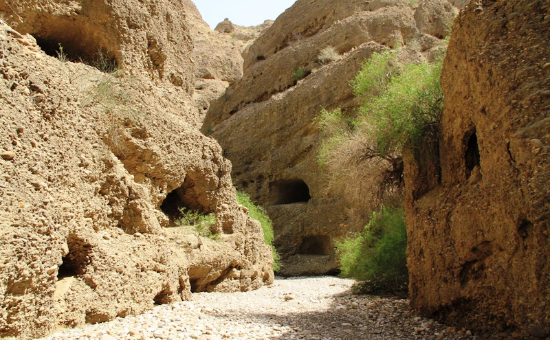
In Balochistan, Pakistan there is a famous archaeological town called “Shehr-e-Roghan” referred to the city of caves or city of Jinns. It is known now as Lasbela, located approximately 175 km from Karachi in the province of Balochistan.  The wilderness of Balochistan had traces of legends heavily influenced by Persian lore that connects the North and South of Pakistan. This is genuinely a true archaeological treasure but unfortunately this amazing treasure is concealed from the world. Different historians narrate Shehr-e-Roghan also called “Gondrani” with the Buddhists of 7th century AD. This amazing archaic cave city is elongating more than an area of three kilometers. Now what is so unique these cave houses are multi storey and are inter connected with each other through sundry walkways every cave house has a solo room and some have a veranda in front.

Different people have different thoughts, however it is said, that in the time of King of Soloman, a beautiful princess “Badiul Jamal” who was possessed by demons. So many princes tried hard to rescue her but could not successes. One day a prince Saiful Malook came and got rid of her tormentors. He vanquished the demons that haunted the Princess in the Cave city and they both left and went to into the North. Many myths are ascribed to this unexplained place. The locals of Shehr-e-Roghan believe that this might be the city of Jinns. With the passage of time, the caves conditions shaped in poor conditions due to high rate of erosion and lack of conservation efforts from the government. There is a grave of an old woman named Mai Balochani who yielded her life to execute the evil presences and recovery the nearby individuals.

A mystical legend says it was a city of huge Buddhist monastery because 1000 years before Buddhism had flourished in this area. In the British regime, more than 1500 rooms were found, which had ample windows and niches made for what historians believed, were for lamps and hearths in the center of the rooms were also found to keep the inhabitants warm. There were also many pathways within the mountain that connected the rooms together. If government gives some attention, then ancient cave city attracts both local and foreign tourists. The local travelers are looking this amazing site for an interesting expedition to explorer the mysteries.  

Therefore, questions still in people minds, that who built these inscrutable caves? Who lived in them? This is still a mystery there is no precise information available but one thing is for sure that this place is extremely marvelous. However, archaeologists and historians thought that the caves have the makings of a Buddhist monastery, probably dating back to the 7th century. So, rumors all over prevails in the recent times, that demons still inhabit the mountains and caves and attack the unwary visitors.


Thursday 8 March 2018

Badwater Basin, The Lowest Point in North America


In the Death Valley, there is an endorheic basin called Badwater Basin, the lowest point in North American with a depth of 282feet below sea level. The Badwater basin comprises of small spring-fed pool next to the road in a sink, accumulated salts of the surrounding basin make it undrinkable, thus giving it the name. The pool site itself does have animal and plant life, including pickleweed, aquatic insects, and the Badwater snail. The area which close to Badwater basin, where water is not always present at the surface, repeated freeze-thaw and evaporation cycles slowly push the thin salt crust into hexagonal honeycomb shapes. This is a popular site for tourists are the sign marking "sea level" on the cliff above the Badwater Basin. Badwater never dries out totally, and even manages to support a unique species of fish - the Death Valley pupfish, a small bluish creature which has evolved to survive in the hot saline conditions.  The salt pools, several routes towards the mouth of the valley, before sinking into the sand.

Moreover, the pool is not the lowest point of the basin; it is actually several miles to the west and varies in position subject to rainfall and evaporation patterns. The salt flats are hazardous to traverse to the sign marking the low point is at the pool instead. The area has extreme temperatures most of the year, but humidity from evaporation of salty water makes all movements more difficult than usual. The shade temperature crosses above 120°F, stands for a while really unforgettable in stifling heat. Be careful when you are walking as some of it can be brittle and break. As soon as you get the large concentration of salt, you can start to see the individual crystals that form with the life cycle of rain and evaporation.

At Badwater Basin, significant rainstorms flood the valley bottom periodically, well covering the salt pan with a thin sheet of standing water. This is the greatest evaporation potential in the United States, meaning that a 12 feet lake could dry up in a single year. When the basin is flooded, some of the salt is dissolved; it is redeposited as clean crystals when the water evaporates. Further low points aren’t usually popular tourist sites, but when you get to claim to be the lowest point in in the United States, it doesn’t matter if you are depressed or just a geography nut, it’s a site to see. So, no trip to Death Valley would be complete without a stop at the lowest point of Badwater Basin, right in the heart of the Death Valley National Park. Source: Charismatic Planet


Wednesday 28 February 2018

Mysterious Ancient Camel Sculptures in Saudi desert

Squinting in the Saudi desert, unprecedented archaeological discovery of camels carved on russet-hued rocky spurs that could shed new light on the evolution of rock art. Almost a dozen humped sculptures, some of them damaged from erosion and vandalism, are probably around 2,000 years old and were recently discovered in a private property along a desert crossing in the northern province of Al-Jouf. The sculptures, which also depict equids, or hoofed mammals, show a level of artistic skill unseen in other rock art forms in the Saudi desert.  This is great work of artistry and creativity, now well known in archeological circles as “the camel site”. Khalifah a researcher explored the site in 2016 and 2017, accidentally found the carvings, when a local friend told him about camel shaped mountain.  Despite detailed artwork, the ancient artists left very few inscriptions or pieces of writing behind unlike at many other rock art locations.
Indeed truly unique and rare camels were carved in the mountain outcrops for centuries venerated as the “ship of the desert “are a familiar motif in artworks from the kingdom. The three dimensional engravings featuring only part of a camel’s body such as the hooves, differ from those discovered at other Saudi sites. Many are perched high on the outcrops and would have required ropes or scaffolding. Moreover, one engraving in specific stands out a camel facing what appears to be a donkey, mule or horse, animals that have rarely been represented in the region’s rock art. The incredible carvings show great skill in their level of naturalism and their sheer size. This discovery may potentially change the understanding of prehistoric population dynamics and cultural traits. However, the site is shrouded in mystery, with little information on who created the carvings or the tools they used. The closest Nabateans tribe known for founding the city of Petra in modern-day Jordan that was carved out of sandstone desert cliffs. In one rock panel there is a camel lying on the ground with its head tilted toward a donkey that is on its feet. The two are nearly touching.
The discovery has shone a spotlight on Saudi Arabia’s rich bedouin heritage. The kingdom is endowed with thousands of examples of painted rock art and ancient inscriptions. This discovery will show variety and richness of the Saudi Arabian past have different styles, which suggests there was more than one artist behind them. Archaeologists say, it is possible, that the Al-Jouf site was one of veneration or on a caravan route used as a resting place or boundary marker. The site is an emblematic place on the regional and caravan routes towards Mesopotamia.  Thus, further fieldwork is now required to find the answers. Many of the eroded sculptures are hard to date, but archaeologists estimate they were possibly completed in the first centuries BC or AD. If they pre-date the domestication of the camel, then they represent wild specimens who may have been hunted, and a successful hunt may have been vital for the survival of the local human populations. Also visible alongside the engravings were painted art forms, which showed human and mythological beings and an object that appeared to look like a chariot.


Wednesday 21 February 2018

The Ancient Bristlecone Pines of the Great Basin


At high elevations in a region of the western United States recognized as the Great Basin. Here is a species of pine lives a quiet, isolated, and exceptionally long life. Bristlecone pines are famous for attaining great ages, have been found that have lived more than 5,000 years longer than any other non-clonal organism. Bristlecone pines are small to medium-sized windblown trees ranging from about 5 to 16 meters (15 to 50 feet) in height Bristlecone pines grow in isolated groves just below the tree line; grow in soils that are shallow lithosols, usually derived from dolomite and sometimes limestone, and sporadically sandstone or quartzite soils. Dolomite soils are alkaline, high in calcium and magnesium, and low in phosphorus.

The trees are extremely hardy, surviving in harsh freezing cold temperatures, being buried in snow, and restorative powerful winds. However, in several cases, portions of the tree can die-off and allow the tree to preserve its limited resources. Hence, Bristlecones aren’t very tall and every so often appear dead or very weathered. Few other plants can grow in the hard rock that Bristlecones prefer, and often the oldest trees are those that live in the most exposed and precarious places. Further, the Rocky Mountain population is sternly threatened by an introduced fungal disease recognized as white pine blister rust, and by pine beetles. The bark of the Great Basin bristlecone pine is characteristically orange-yellow to light brown, whereas that of the Rocky Mountain bristlecone pine is typically gray-brown. The female cones are ovoid in shape and deep purple when young; they mature to a pale brown and bear a characteristic bristle on each scale.

Although, one thing they can’t last is chainsaws. In what is now the Great Basin National Park of eastern Nevada, a tree known as “Prometheus” was being studied by a group of ecologists. Experts drill cores out of trees in order to count and measure the rings that chronicle their growth. Thus, much about the tree’s life and the ecological conditions in the area can be derived from these samples. Unluckily, when Prometheus was drilled for a core, the tool used for this process broke off inside. The investigator needed his tool back and to get it, he had to cut the tree down. Once he’d retrieved his tool and the core from Prometheus, he was able to define that the tree had lived 4,862 years longer than any other single living organism.

Moreover, an older tree hasn’t been found since, though one recognized as Methuselah is believed to be about 4,850 years old and its specific location is also being kept secret. Most of the living groves of these trees are under better protection now and can be visited in numerous locations throughout the Great Basin and in California. The other two species, Pinus balfouriana and Pinus aristata are also long-lived; specimens of both have been measured or estimated to be up to 3,000 years old. The study of the wood of these ancient trees has revealed environmental conditions stretching back to almost 9,000 years ago.


Monday 19 February 2018

Spook Hill ! Florida's


Spook Hill is located on the Lake Wales Ridge, (about 50 miles south of Disney World) a geologically significant range of sand and limestone hills, which were islands from two to three million years ago, when sea levels were much higher than at present. The Legends abound regarding this landmark, and famous as a magnetic hill, anti-gravity location or simply a “gravity hill” a car, placed in neutral, will appear to roll uphill  Spook Hill is  an optical illusion where cars appear to roll up the spooky hill. Spook Hill is located directly across the street from Spook Hill Elementary School, which conveniently adopted "Casper the Friendly Ghost" as their school mascot. The Friendly Ghost as their school mascot. Before the age of automobiles, horses would supposedly struggle to go downhill. The town embraces and officially recognizes the hill’s curious properties.

The attraction is also in close proximity to Bok Tower. Spook Hill received national media attention when an article about it appeared on the front page of the Wall Street Journal on October 25, 1990, and it was featured in a segment on CBS Morning News with Charles Osgood on November 5, 1990. The Legends believe that an Indian chief battled an alligator that had been terrorizing the local village. The fight was outwardly so intense that both combatants eventually died, on top of the hill. The legends are split as to whether it is the chief or the alligator’s spirit that haunts the hill. In reality neither chief nor alligator are responsible for the hill’s anti-gravity properties, but like all other anti-gravity spots is the result of a unusual optical illusion. Moreover, you should read the cute sign, drive slowly to the white line in the road, stop, put your car in neutral and BE CAREFUL looking backwards as your car mysteriously rolls uphill and you try to keep your car in the middle of the road and not crash into another dumb tourist.


Wednesday 31 January 2018

The Scared Devils Tower

Devils Tower National Monument, a unique and striking geologic wonder steeped, is a modern day national park and climbers' challenge, one of the most remarkable natural creations. Devils Tower is a laccolithic butte composed of igneous rock in the Bear Lodge Mountains near Hulett and Sundance in Crook County, northeastern Wyoming. The Devils Tower is also called Mato Tipila, which means “Bear Lodge”. The scared devils tower is an astonishing geologic feature that protrudes out of the prairie surrounding the Black Hills. Numerous ideas have evolved since the official discovery of Devils Tower. Geologists came to the conclusion that the Tower was indeed formed by an igneous intrusion. Other ideas have suggested that Devils Tower is a volcanic plug or that it is the neck of an extinct volcano. Though there is no evidence of volcanic activity - volcanic ash, lava flows, or volcanic debris - anywhere in the surrounding countryside.
Devils Tower is 386 meter above the surrounding terrain and the summit is 1,558 meter above sea level. The 1.25-mile Tower Trail encircles the base. Geologists have faith in that the tower is the eroded remains of a large mass of igneous rock poking through a layer of overlying sedimentary rock beds. Devils Tower is considered sacred by Northern Plains Indians and indigenous people. Hundreds of parallel cracks make it one of the finest crack climbing areas in North America. Devils Tower is US first national monument, as most of peoples have gazed at the Tower and wondered, "How did this amazing formation form?" This self-guided hike offers close-up views of the forest and wildlife, not to mention spectacular views of the Tower itself.
During rain and snow continue to erode the sedimentary rocks surrounding the Tower's base, and exposed more. Although Devils Tower has been eroded over the ages, and portions, or even entire columns, of rock are continually breaking off and falling. But at the same time, the Tower itself is gradually being eroded. Rocks are continually breaking off and falling from the steep walls. Rarely do entire columns fall, but on remote occasions, they do. Piles of rubble, broken columns, boulders, small rocks, and stones, lie at the base of the Tower, indicating that it was, at some time in the past, larger than it is today.
Moreover the piles of scary devils towers are broken columns, boulders, small rocks, and stones lie at the base of the tower, indicating that it was once wider than it is today. The Ladder at Devils Tower was first constructed and used in 1893 by William Rogers and Willard Ripley to publicly ascend Devil's Tower. Devils Tower entices traveler to learn more, explore and define place in the natural and cultural world.


Tuesday 30 January 2018

Wave Rock, Australia


Wave Rock is a strange natural rock formation located east of the small town of Hyden in Western Australia. Wave Rock name derives from the fact that it is shaped like a tall breaking ocean wave, composed of granite and the total outcrop covers several hectares. The wave rock is about 15 meters high and about 110 meters long. Wave Rock is a remarkable example of what geomorphologists call a "flared slope". A flared slope is a concave-upward or -inward bedrock surface that is naturally found around the base of inselbergs, bornhardts, and granitic boulders and also on their higher slopes. Wave Rock is 27 million years old and made up of grey and red granite strips, is quite a formation aboriginal rock paintings can also be seen at nearby Bates Cave.

The shape of the rock is not caused by a wave phenomenon, rather its rounded wave-like shape was formed by subsurface chemical weathering followed by removal of the soft weathered granite by fluvial erosion, and therefore the weathering occurred below ground level before it was exposed. The end result is an undercut base, leaving a round overhang. Further, in the spring season, water running down the rock during wetter months dissolves minerals adding to the coloring of the wave. Moreover the other aspect of Wave Rock not often shown on photographs is the retaining wall about halfway up the rock. This follows the contours and lets rainwater to be collected in a storage dam. It was constructed in 1951 by the Public Works Department, and such walls are common on many similar rocks in the Wheat-belt region of Western Australia. You will find interpretive signage around the rock; enlighten you on the history of the rock and surrounding areas. In the spring, one can find many orchids and other flowers growing around the base in the Sheoak trees.