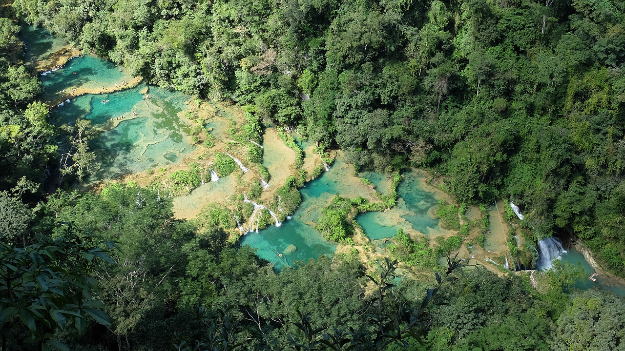
Tuesday 29 March 2016

Semuc Champey; Guatemala

Semuc Champey, consists of natural 300 m limestone bridge, a natural monument in the department of Alta Verapaz, Guatemala near the Q’echi’ Maya town of Lanquin. The Cahabon River passes under the bridge, and atop of bridge a series of stepped, turquoise pools. Semuc Champey, which in the language of the Maya means “sacred water,” and another name for it might well be heaven. Semuc Champey is a natural wonder tucked away in the mountains of an isolated jungle in Guatemala where the harder rock on the surface has held strong while the river eroded the softer rock beneath.

It’s a famous swimming place among visitors and getting more popular as the time passes. The pools naturally created by Cahabon River which turquoise color and Muddy River runs beneath them and out the bottom of a larger waterfall on the other end. The pools water is so clear, as it is rain water and river may flood over the pools as well. The natural limestone bridge & turquoise blue pools of Semuc Champey had revealed themselves where you can get a great view of the scenery around you. The Cahabòn River water color is incredible a strong bright turquoise blue that sharply stands out from the surrounding green jungle.

So, you should be very careful to get close to the edge, as few people have fallen in here before, never to be found again. Due to this sad incident, the park has hired a guy who stands near the hole and warn you with whistle not go to edges. Make sure to dip into pools, some areas are deep enough to dive into from high points on the limestone shelf. The limestone's have small caves too, and you can swim and enjoy into them and explore from underneath a waterfall. There’s slight sunlight outside reflecting from the bright blue water to give you beautiful view.

This is the perfect place which had inspired visitor’s quest, a source of fascination and trepidation and it looks like Mother Nature’s amusement park. In spite of staggering beauty the place is so cut off but most extraordinary spot you’d have ever seen. A tangle of greenery with lovely parrots in the trees, monkeys, an underground river, miles of stalactite-and-stalagmite-filled caves orchids in the trees, butterflies fluttering: if there was an Eden on earth this might be it.

Monday 28 March 2016

The Incredible Hydrothermal Fields of Ethiopia

The hydrothermal fields of Ethiopia look like landscape of an alien plant. The amazing photographs of Dallol Volcano in Ethiopia look out of world. Dallol is actually hydrothermal field, is an endless yellow orange landscape, craters stretching for several miles around. The volcano fields are located in the northern Danakil depression. This part of world has too many hot springs which discharge brine and acidic liquid. However almost 150 feet below sea level, Dallol’s craters lowest known subaerial vents in the world, the explosion crater are was formed by the intrusion of basaltic magma in Miocene salt deposits and subsequent hydrothermal activity.
A German based photographer Adrian Rohnfelder, who is curious to look something special in Ethiopia to, fulfilled his desire to shoot active lava lake. He was self-proclaimed lava hunter to shoot lave lake of Erta Ale, another volcano in Ethiopia. Adrian visited this part of world at the end of Feb 2016. He said, I’m really amazed and blown by Dallol, what an incredible view, a massive huge area full of bright colors, like orange, yellow, red, green, blue and white. I was totally stunned and thought this planet is far away on the other side of our milky way, it’s scene I have never seen before.

I took the gorgeous images of lave flowing from volcano Erta Ale, located in the Afar region. Moreover, as well as Dallol's lively landscape alike to the hot springs of Yellowstone Park in the U.S. Therefore, Erta Ale continues Lava Lake has been active from past several decades. I’ve been becoming interested in volcanoes since 2005, the photographing of active lava lake of Erta Ale has long been a dream. Because, volcanoes let me feel the real power of nature in every sense, the ear battering explosions, frightening shockwaves, falling lava bombs and the agonizing heat of nearby floating lava, including the optical spectacle of infinite fireworks. You know, “Erta Ale” volcano with one of the very rare persistent lava lakes on earth of course has been on the top of my volcanic bucket list.

Thursday 24 March 2016

Taq-e-Kasra The Arch of Ctesiphon


The ancient city of Ctesiphon (Also known Tusbun or Taysafun) on the banks of Tigris, in Baghdad established in the late 120s BC. The city is located about 35 kilometers southeast of modern Baghdad actually one of the great cities of late ancient Mesopotamia and the largest city in the world from 570 AD, until its fall in 637 AD. So during the Muslim conquest the only surviving structure of Ctesiphon these days is the majestic vaulted hall of Taq Kasra, which served as the palace of the Sasanian king Khosrow I, in the late 6th century. The archway is one of the biggest single-span vaults of unreinforced brickwork in the world. The exact time of construction is not known with conviction. However, it is believed that construction possibly started during the reign of Khosrau I after a campaign against the Byzantines in 540 AD.

Mithradates was founded Ctesiphon, “the King of Parthian Empire” as a royal residence, after he annexed Babylonia by defeating the Greeks. Therefore, under the Parthian rule, Ctesiphon became the political and commercial center of the region, and by the end of 58 BC, it had become the Empire’s capital. Progressively, the city was merged with the old Hellenistic capital of Seleucia and other adjacent settlements to form a cosmopolitan metropolis. Moreover, in the 2nd century, the tug-o-war of power between the Romans and the Parthians affected Ctesiphon to change hands between the two Empires for a total of six times. 

Though the obliteration of the palace is blamed on different individuals by numerous sources, Abbasid caliph Al-Mansur (754-775) is most usually mentioned. However, during the last possession, the Romans kick out and looted the city, demolished palaces and carried off thousands of its inhabitants as slaves. Consequently, in 226 AD, the city fell into the hands of the Sasanian Empire, and Ctesiphon prospered once again. The oldest occupied places of Ctesiphon were on its eastern side, which in Arabic sources is named "the Old City", where the residence of the Sasanians, identified as the White Palace, was located. The southern side of Ctesiphon was recognized as Aspanbar, which was acknowledged by its protuberant halls, riches, games, stables, and baths. 

Thus, after another short-lived occupation of the city by the Romans, the Sasanian king Khosrau I recuperated control over Ctesiphon. He then underway building a large palace complex with a large vaulted arch that is 37 meters tall and 26 meters across. The arch top is about one meter thick while the walls at the base are up to seven meters thick. Up to modern times, it was the largest, unverified vault in the world. Besides, after the Arabs took Ctesiphon in 637 AD, they improvised the palace as a mosque until the area was slowly abandoned. Hence, by the end of 8th century, Ctesiphon had been superseded by the lately founded city of Baghdad, and Ctesiphon’s deserted ruins were used as a quarry for building materials. Consequent floods demolished all remaining structures, including Taq Kasra, one third of which was swept away by a flood in 1888.

Henceforth, the striking brick ruin of Taq Kasra is now all that remains above ground of a city that was, for 7 centuries the main capital of the Iranian successor dynasties of the Parthians and Sassanids. In the 1980’s the archway rebuilt process was started by Saddam Hussein's government when the fallen northern wing was moderately rebuilt. Therefore, all works somehow stopped after the 1991 Gulf War. In 2003, before the US-led invasion the area boasted gardens and arbores, as well as a popular museum. In 2004, the Global Heritage Fund said that, as a result of disrepair, the arch was “in danger of collapse”. Taq-e-Kisra was neglected for a long time and decided to rehabilitate it. However, the current Iraqi government is cooperating with the University of Chicago's "Diyala Project" to revive its reputation as a tourism hub has proceeded in fits and starts.

Tuesday 22 March 2016

Cat Island Japan


An army of cats rules the remote island curling up in abandoned houses or strutting about in a fishing village that is overrun with felines outnumbering humans 6 to 1. Tashirojima is a small island in Ishinomaki, Miyagi, Japan, lies in the Pacific Ocean off the Oshika Peninsula, to the west of Ajishima. This is also known as “Cat Island” has long been thought by the locals to represent luck and good fortune. The island is also known as Manga Island, as Shotaro Ishinomori built manga-related buildings on the island, resembling a cat. If you take care of them and feed well, and treated like kings or as pets will bring wealth and good fortune.  So, it is not an accident that the cats that inhabit have come to be the island's primary residents and most are feral because keeping them as "pets" is generally considered inappropriate; they’re well-fed and cared-for. In 2012, the BBC in the United Kingdom, presented a short television series called Pets “Wild at Heart”, which features the behaviors of pets, including the cats on the island.

Moreover, in the last 60 years or so, the human population of island has significantly decreased from few hundreds to thousands. The cat population is now larger than the human population on the island. The number of inhabitants has shunned the island as it became dominated by felines. The populations which have left have become more protective of the cats. Moreover another interesting that, dogs are not allowed here just to protect cat’s well beings and apparently any dog foolish enough to venture onto an island full of feral cats. Due to cats, the island has become a popular attraction for curious travelers.In 2011, the famous Tohoku tsunami has damage the island, but feline population has become survived and intact and several believe, the island wasn’t destroyed due to cats luck.

In the Period of Edo in Japan, the much of island raised silk worms for their textile needs and they use to kept cats to chase the mice away from their precious silk worms in order to keep the mouse population down because mice are a natural predator of silkworms. Moreover there’s a small shrine known as Neko-jinja in the middle of island. Hence, there are at least 10 cat shrines in Miyagi Prefecture and are also 51 stone monuments in the shape of cats, which is a strangely high number, compared to the other prefectures. Therefore, these shrines and monuments are concentrated in the southern area of the island, overlapping with the regions where silkworms were raised. As a result, the cat lovers come to the island and package tours exactly to "look for Jack" are now available. Thus, Cat photographs contests and exhibitions are now held on the island.

Monday 21 March 2016

KeriĂ° Crater, A Volcanic Crater Lake in Iceland

KeriĂ° is a volcanic crater lake located in the Grimsnes area in South Iceland. It is also known as Kerith or Kerid, a popular tourist attraction due to scenic route Golden Circle. There’re number of crater lakes in the Iceland’s Western Volcanic Zone, which includes Reykjanes Peninsula and The Langjökull Glacier. It is one of several crater lakes in the area, known as Iceland's Western Volcanic Zone, which includes the Reykjanes peninsula and the created as the land moved over a localized hotspot, but it is the one that has the most visually recognizable caldera still intact. This is a 55 m deep explosion crater that harbours a small green lake in the GrĂ­msnes region, filled with water; steep circular slopes resemble an ancient Amphitheatre. The crater is nearly 3000 years old, often displaying intense colors. The caldera is well composed of a red and black volcanic rock. The caldera is approximately 180 feet deep, 560 feet wide, and 890 feet across. KeriĂ°’s caldera is one of the three most recognizable volcanic craters. However, the other two surrounding volcanic are SeyĂ°ishĂłlar and KerhĂłll half the age of this.

While most of the crater is steep-walled with little vegetation, one wall is sloped more gently and blanketed with a deep moss, and can be descended fairly easily. The fairly shallow lake approximately is seven to ten meters deep, but mainly depending upon rainfall and other factors.  However, the other minerals from the soil, is an opaque and strikingly vivid aquamarine. Researchers originally thought that KeriĂ° is formed by a massive volcanic explosion, though no evidence found to proof such an explosion in KeriĂ°. Therefore, currently it is believed that KeriĂ° was a cone volcano which was erupted and emptied its magma reserve. Hence once the magma was depleted, the weight of cone collapsed into empty magma chamber. So, the existing pool of water at the bottom of the crater is at the same level as the water table and is not caused by rainfall. The stunning beauty of Kerid Crater Lake proves that Southern Iceland is not all about ice and fire. This is one of most amazing photograph landscape protected from weathering, the jagged rocks and fissures of the walls stand in sharp contrast to the gentle rolling landscape nearby. The best way to see Kerid crater is to travel along a popular tourist route called the Golden Circle, a 300-kilometer loop that covers the most amazing natural sites in southern Iceland. Moreover, fish probably don’t live there, but there are zooplanktons and you can stand at the top of the crater and look down at the eerie calm of the lake below.

The sides of the crater are really steep but a few daring tourists always decide to climb down to the depths. Well, if you climb down into the crater, then please be careful since it was moderately difficult to navigate way to the bottom. Thus, once you get to the bottom, you can stand by the lake and observe how the sides of the crater create a cocoon for sound. The wind and nearby road are silenced by the natural walls of the crater. The bottom of the crater feels peaceful with the quiet and static water. It was definitely a meditative location.  But the really difficult part is getting back up the 55 meters to the top again. Kerid Crater is a quirky little stop-off and great because it’s not busy like the other attractions on the Golden Circle.