Showing posts with label England. Show all posts

Monday 14 March 2016

The Twin Sails Bridge


The Twin Sails Bridge is a double leaved bascule bridge that spans the Backwater Channel in Holes Bay linking the town center of Poole, in Dorset, England, to Hamworthy. In the closed position, the bridge lays flat over its supporting pillars, nonetheless when the two spans of the bridge are lifted to permit boats to pass, the two triangular lifting leaves look like the sails of a yacht. However, the triangular shape is caused by the fact that the bridge isn’t dissected perpendicularly across its width, but at an angle, making two long, opposing triangles that lie side by side. Therefore, when the bridge is opened, they rise skyward, like a pair of masts opening their sails.

The two triangular leaves measure 23 meters each, and when lifted, they provide a clear channel 19 meters wide for boats to pass through. The lift spans are powered by two hydraulic rams which operate up to 15 times per day, and take two minutes to fully open. The bridge was built and opened to traffic in April 2012, after nearly three decades of deliberation, approvals and cancellations. The plan for the construction of a new bridge was initiated in the 1980s. The current bridge, which was built in 1927, was facing heavy congestion due to increasing traffic levels. Thus, at first a fixed bridge crossing Holes Bay and linking with the A31 was proposed but it got cancelled in 1998. Moreover the idea of the second lifting bridge was put forward in 2004, and got approval in 2006, however instantly went into hold due to issues between the council and the land owners. So, when everything was cleared and parties had agreed, construction of the bridge commenced in 2010.

The bridge was designed by architect Wilkinson Eyre and constructed by Hochtief (United Kingdom) Construction, at an expense of £18.5 million. Furthermore, the project acknowledged the outstanding achievement award for exterior lighting at the Architecture Lighting Design Awards 2012. Moreover it was also nominated among the top four final bridges selected at International Institute of Structural Engineers Awards 2012, as well as being nominated under the commendation category for its structural authenticity.

Sunday 7 February 2016

The Devil’s Elbow, A Forgotten Notorious Double Hairpin Bend


A former stretch of road in Scotland that was so dangerous that it earned the nickname “The Devil’s Elbow” is an attraction for adventurous holidaymakers. The Devil's Elbow, is notorious double-hairpin bend often-quoted gradient of 33 percent is a myth. The modern road bypasses the hairpin bends, but the old road still exists and its route can be walked, or carefully cycled. Though the forgotten historic road overgrown with weeds and slowly disappearing, yet still heavy with the memories of its earlier life.

However, the once be scared double-hairpin bend near Glenshee, Perthshire, Braemar, and Aberdeenshire used to be part of Britain’s highest route, the A93, nonetheless was bypassed when the road was straightened out in the 1960s much to the relief of motorists. However, this road is often blocked by snow in the winter. The beauty of this road still exists, and entices hikers and cyclists, so officials are trying to bring in more tourists with a new rest stop and walking routes. The Devil’s Elbow is located a mile south of the 2,198ft Cairnwell Pass. 

However, once the double hairpin bend was Britain’s most challenging stretch of road, with warning signs push drivers to show “great caution”. In 1967, the Devil’s Elbow gets more famous, when Queen Elizabeth II is being driven to Balmoral by Prince Philip, as crowd’s wave from the roadside.  The British A93 is regularly used by classic car and motorbike fans and increasingly cyclists. Therefore, the newly planned construction will give a new life to this scenic route along eastern side of Cairngorms National Park. The tourists will motivate to get new experience and relish the breath taking landscapes of the Cairngorms. 

Sunday 3 January 2016

Northumberlandia: The Lady of the North East England


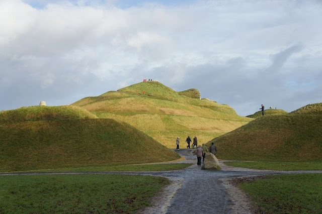
Meet the supine, the Lady of the North the former coal mining town of “Cramlington, Northumberland”, North East England, is a massive piece of land art in the shape of reclining lady named “Northumberlandia”. The lady is more than a hundred feet tall at her tallest point, her forehead, and a quarter of a mile long. The Woman lies on her back, with her long hairs spread out, upper body in supine position and her lower torso twisted towards her left, as it looks like that she is dancing. It is created by American landscape architect and designer Charles Jencks, “Northumberlandia” is said to be largest human landform sculpture in the world. It is officially opened by a woman “Princess Anne” in September 2015, it has become an apparent hit, with 25,000 visitors in its first few weeks.

Hence, “Northumberlandia” was shaped from the by-products of an opencast mine in “Shotton” well owned by Banks Group and Blagdon Estates. Whereas digging for coal the employers feels that there was a fabulous opportunity to imaginatively reuse all the rocks and dirt dug out of the ground in its place of dumping them into bland hills. Therefore, they contacted famous artist “Charles Jencks” to see what could be done and Northumberlandia was born.

However, it took Charles Jencks 2 years to build and shape her shapely figure and bodily limbs out of 1.5m tonnes of rock, clay and soil redundant from the mine. Therefore, her core is made of rocks, layered over with clay and topped with soil over which an excellent grass grows now. Moreover, some of her features are beautifully artistically highlighted with stone from the mine that is frequently used for the restoration of old buildings. Thus, the figure provides a series of resting and viewing platforms, the uppermost on the forehead, from which you can get a view of the open cast mine from where she came.


Thursday 10 December 2015

Malham Cove Waterfall Restore after 200 Years


The beautiful natural limestone amphitheater Malham Cove in the village of Malham, North Yorkshire, England, was lovely carved by a waterfall carrying meltwater from glaciers at the end of the last Ice Age more than 12,000 years ago. This was a massive waterfall almost 80 meters tall and more than 300 meters wide. Nowadays, this famous majestic beauty spot is as dry as a bone as water flows through cracks and tunnels within the limestone cliff to begin at the foot of the limestone cliff well before it reaches the cliff edge. Therefore, it was an ancient waterfall recently brought back to new life for a brief period by Storm Desmond that has been raging across Great Britain since December 3 2015. However, nobody remembers for definite when the waterfall was last flowed.

Therefore, some legends say it was probably two hundred years ago, when it was overwhelmed by the nonstop rainfall, water flowed over the top of the white limestone rocks of Malham Cove, fleetingly making it England's highest unbroken waterfall. Malham waterfall drop is around two-and-a-half times bigger than England's current record holder, “Hardraw Force”, also in the Yorkshire Dales, which measuring around 30 meters. Moreover Martin Davies, the general manager of the National Trust Malham Tarn Estate, said the waterfall may have already finished flowing but could possibly start again when additional heavy rainfall is predictable on future. Therefore local peoples are praying to restore the era of waterfalls to boost the tourism. 


Monday 2 November 2015

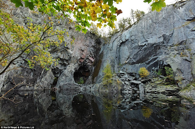
The Haunting Cliff face Appear to be Giant Skull When Reflected in Still Waters of Lake District


The frightening sight of a massive skull has been spotted in the rocks of a remote area of the Lake District which is believed to have claimed the lives of countless divers. The terrifying cliff face and its eerie reflection in the waters of the lake create mysterious illusion of a sinister skull on its side emerging from the darkness. Therefore, the hunting picture can be visible in the still water of disused Hodge Close slate quarry near Coniston in Cumbria. Thus, the abandoned quarry, which is 70 metres deep from the surface and has a 20 metres deep lake, is pierced with underwater tunnels. Hence, the quarry was an open pit from the 19th century to the early 1960s which has now flooded over time. Nowadays, this place is well known in divers and abseilers who’re keen to climb the rock face, though access to the water involves wading through a 120 metres flooded tunnel and down a scaffolding ladder. Several legends believe, that the lake has claimed the lives of quite a few divers over the years that have gotten lost in the tunnels.

A 45-year-old man had to be rescued after falling 20ft while abseiling in the quarry in 2012. He was rescued during a hardworking two-hour operation by a team of 20 members of Coniston Mountain Rescue Team. So, no one knows how many people have seen or noticed the skull. Therefore, it is only really becomes visible when the water is flat calm, and you look at the view sideways. You also need to be down next to the water, which isn't a trip everyone would want to make. Though, the quarry stopped working in the early-to-mid 20th Century, and is a prevalent climbing and diving venue. It is frequently used as an abseiling location by outdoor instructors. There’s stillness and a very eerie atmosphere around the place. The area is uses for training for various aspects of rope rescue and familiarization to allow us to respond effectively to incidents at the quarry and can't see the skull reflection from the top you have to scramble down to the pit of the quarry and walk to the water’s edge to see it. When you look at the reflection of the skull in the deep dark water, it's quite chilling. However, bearing in mind the status of the area, it is a very worrying moment when the skull appears out of nowhere with crystal clarity.