Pages

Tuesday, 30 October 2018

The Lake Tiberias (Sea of Galilee), Northern Israel


The Sea of Galilee (Lake Tiberias) is a magnificent geographical marvel surrounded by pretty rural agricultural settlements. It is not a real sea - it is called a sea because of tradition. Lake Tiberias is largest fresh water lake in Israel’s. The lake measures 53 km in circumference 21KM north-south and 141 feet deep. The Lake Tiberias (Seas of Galilee) is partly fed by underground springs related to the Jordan sector of the Great Rift Valley. The maximum water comes from the Jordan River. Which is winding course can be seen draining the south end of the lake at bottom. The Jordan River rises on the slopes of Mount Hermon, on the border between Syria and Lebanon, and flows southward through northern Israel to the Sea of Galilee. Thus, the other streams and wadis (seasonal watercourses) flow into the lake from the hills of Galilee.

Lake Tiberias is also famous as the Sea of Tiberias, Lake of Gennesaret, Lake Kinneret, and the Sea of Galilee. This is the lowest freshwater lake on Earth and the second-lowest lake in the world after the Dead Sea. Lake Tiberias is situated between Golan Heights and Galilee region in the Jordan Rift Valley. This is area has the history of volcanic history evident by the abundant basalt and igneous rocks that define the geology of Galilee. The Lake Tiberias warm water supports various flora and fauna. That supported commercial fishery for over 20 years. The notable fish species to be found include damselfish, scaleless blennies, catfish, mouthbreeders, and barbels. Sea of Galilee is one of the earliest settled areas and brags archaeological ruins sitting together with some of the first pioneering settlements in Israel, as well as religious sites, modern cities, and endless outdoor pursuits.

Sea of Galilee has severe drought as of 2018 from many years. The Lake Tiberias is expected to get to the black line the lowest depth from which irreversible damage start and no water can be pumped out anymore. However, in Sep 2018 the Israeli energy and water office announced a project to purr desalinated water from the Mediterranean Sea into the Sea of Galilee. They will be using an underground tunnel expected to be largest of its kind done in Israel. This project will transfer half of the Mediterranean desalted water and will push 300 to 500 Million cubic litters of water per year. Three-quarters of the drinking water consumed by Israeli households comes from these desalination plants.

The Sea of Galilee, has suffered from four consecutive years of rain shortages, make the water situation is serious. The lake has fallen to its lowest level in 100 years. The Israeli government monitors water levels and publishes the results daily at official web site. The Lake Tiberias is at risk of becoming irreversibly salinized by the salt water springs under the lake. Which are held in check by the weight of the freshwater on top of them? Tourism around the Lake Tiberias is an important economic branch.

The religious and historical sites draw both local and foreign tourists. Due to Lake sheltered location, low elevation, the winters are mild, with temperatures averaging 57 °F in January. The summers are hot, with temperatures averaging 88 °F (31 °C). Also the absence of freezing temperatures has facilitated the cultivation of bananas, dates, citrus fruit, and vegetables. The shortage of rainfall is affecting agriculture, the environment and animal life in the nearby area. About five miles on the east side of Sea of  Galilee there is Hamat Gader situated – a hot springs one of Israel’s most popular attractions. With mineral springs of up to 50 degrees, there have been ancient baths here for almost 2000 years. There is also an alligator and rare exotic bird reserve. The region also has loads of hiking trails, including Sea of Galilee Trail which encircles the lake.

Lake Tiberias in Islam

One of major point is mentioned in Islam that sea Galilee will drying up actually is one of the signs of end of times! The disappearing Sea of Galilee and Emergence of DAJJAL the Anti-Christ, Prophet Muhammed (PBUH) told humans 1400 years ago! When the Sea of Galilee dries up the Prophet Isa (A.S) will return and Gog and Magog will drink the entire water and then thy will be destroyed. The prophecy of the drying up of Lake Tiberias (Sea of Galilee) is established from two authenticHadith


Sunday, 28 October 2018

Jeju Island, South Korea

Jejudo Island is also known as Jeju Island in Korean Peninsula. Jejudo (also known as Jeju Island) is a volcanic island. Jeju Island has a surface area of 1,846 sqkm. It is the largest island 130 km off the coast and the main island of Jeju Province of South Korea. The island was formed entirely from volcanic eruptions approximately 2 million years ago. The area mainly consists of basalt and lava. The island contains the natural World Heritage Site Jeju Volcanic Island and Lava Tubes. Jejudo has a moderate subtropical climate, even in winter the temperature rarely falls below 0 °C.
 
It is warmer then rest of Korea with four distinct weather seasons. Winters are cool and dry while summers are hot, humid, and sometimes rainy. Moreover, 95% of all rocks and stones on land today are made from lava, as you can see from the dark color and natural holes or erosion on the surface of the rocks. Jeju’s natural landscape, from its volcanos, to mountains and valleys, make it a hiking paradise.

It is a popular holiday destination and a sizable portion of the economy relies on tourism and economic activity from its civil/naval base. A central feature of Jeju is Hallasan, the tallest mountain in South Korea and a dormant volcano, which rises 1,950 m above sea level. 360 satellite volcanoes are around the main volcano. Historically, the island has been called by many different names. The Jeju Island mind-blowing nature and surreal landscapes has given it the prize of 3 UNESCO sites and, most notably, listed as one of the 7 new wonders of nature! 
 
Jeju island has only 600,000 residents – which is roughly 3% of Seoul’s population on land that’s 3X the size of Seoul’s metropolitan area. There is no hustle and bustle. There are no tall skyscrapers. There are no honking horns, or even traffic for that matter. Nobody in Jeju in a hurry — which is a really nice change of pace from bustling Seoul. Despite attempts to market the island as "the Hawaii of Korea," climatologically and geographically it bears little in similarity to the Hawaiian Islands in the U.S.

It’s no surprise that Jeju is a popular honeymoon destination for both Koreans and foreigners. The island is built for romance. Cute coffee shops, restaurants, stores and even a theme park called Love Land! Jeju island is in such high demand that there are more daily flights from Seoul to Jeju than any 2 destinations in the world – can you imagine that? The island offers visitors a wide range of activities: hiking on Halla-san (South Korea's highest peak) or Olle-gil(routes), catching sunrises and sunsets over the ocean, riding horses, touring all the locales from a favorite television K-drama, or just lying around on the sandy beaches.


Saturday, 27 October 2018

Lonar Lake, India


Lonar is one of Maharashtra’s best-kept secrets. Lonar Lake is incredibly 50,000 years old lake. Lonar Lake is also called Lonar Crater is the youngest and best preserved impact crater formed in basalt rock and is the only of its kind on earth. The crater was formed fifty-two thousand years ago, when a gigantic meteor crashed into the earth at an estimated speed of 90,000 km per hour. Lonar Crater has a mean diameter of 3,900 ft and is about 449 ft below the crater rim, and meteor crater rim is about 1.8 KM in diameter.

The Lake is mainly fed by Dhara and Sita Nahani streams. The Lonar Crater is protected as a geological landmark and authorities have recognized the role of the historical and archaeological heritage in the lake. The lake water contains various salts or sodas, and during dry weather when evaporation lessens the water level, large quantities of soda are collected. The Lonar crater has an oval shape and its meteorite impact came from the east, at an angle of 35 to 40 degrees. The saline deposits obtained from the lake are rather of an exceptional nature.

The salts collected from this lake vary in their nature and composition and from their-appearance are effortlessly separated by men accustomed to handling them. The Lonar Lake is home to a horde of algae and plankton species that thrive in its unusual ecosystem and give the water its vibrant color. Most tourists come to nearby Aurangabad to visit the Ajanta and Ellora UNESCO World Heritage Sites, but never make it as far as Lonar.

Over time, the jungle took over the deep depression, and a perennial stream transformed the crater into a tranquil, emerald green lake. Today, the forest-fringed lake is located in the Buldhana District of Maharashtra. The lake was initially believed to be of volcanic origin, but now it is recognized as an impact crater created by the hypervelocity impact of either a comet or an asteroid.  The lake water is polluted by using of fertilizers, pesticides and toxic material in the agricultural field. 

The lake has wildlife sanctuary with a unique ecology that is vastly different from the surrounding flat landscape. Its water supports micro-organisms rarely found elsewhere on earth while its surroundings are peppered with fragments of unique minerals like maskelynite. The local peoples are destroying Lake Eco system, by bathing, washing clothes and drinking water by cattle’s and disposing detergents in them. Deforestation and excavation also carried out here and cattle grazing inside near him create fecal pollution cause environmental damage to nearby land.

Marauding pilgrims and increasing pollution is disturbing its substantial flora and fauna with about 100 resident and migratory birds. Furthermore lonar lake ecosystem is being damaged because of the sewage dump in the lake. Also commercial activities, including illegal construction, within the vicinity of lake has damaged the lake's natural topography. There is a small circular depression at a distance of around 700m from the main lake, believed to be caused by a splinter of the meteor that hit the ground to also make a crater.

The Lonar Lake is also home to thousands of peafowls, chinkara and gazelles. The natural lake is a heaven for a many species of plant and animal life. The migratory and resident birds such as black-winged stilts, grebes, shelducks, shovellers, teals, herons, red-wattled lapwings, blue jays, baya weavers, parakeet hoopoes, larks, tailorbirds, magpies, robins and swallows are found on the lake. Also among reptiles, the monitor lizard is reported to be the most prominent. Lonar Lake is one of the most exclusive landmarks on the world. Hence, it is slightly out of the way, but totally worth it.

Before you go there, keep in mind that March till May are the hottest months in Maharashtra, and temperatures can climb upwards of 40°C. Occasional. However monsoons normally starts in June and can go on up to September. The heavy rainfall took place in July. Hence, winter starts from Oct till Feb is mild, with clear skies, gentle breezes and average daytime temperatures that range between 12-25°C. The views of this stunning Crater Lake, the only one of its kind in the world, are bound to give wings to your imagination.


Saturday, 20 October 2018

Aogashima! A Volcanic Japanese Island

Aogashima is a volcanic Japanese island in the Philippine Sea, administered by Tokyo. The island's area is 8.75 km2 and, its population is about 200.  Aogashima is a volcanic island 3.5 km in length with a maximum width of 2.5 km. Aogashima is also within the boundaries of the Fuji-Hakone-Izu National Park. Aogashima is approximately 358 kilometres south of Tokyo and 64 KM south of Hachijō-jima. It is the southernmost and most isolated inhabited island of the Izu archipelago. The village of Aogashima administers the island under Hachijō Subprefecture of Tokyo Metropolis. In the center of the island lies a geothermal sauna, scuba diving is popular, and the alien landscape is something you will never forget.

The island was the site of a series of earthquakes, known as an “earthquake swarm” in the 1780’s and a large eruption in 1785 that killed 130-140 people, nearly half of the island’s population. This island is formed by the overlapping remnants of at least four submarine calderas. The island is surrounded by very steep rugged cliffs of layered volcanic deposits. The southern coast also rises to a sharp ridge forming one edge of a caldera named Ikenosawa with a diameter of 1.5 km. The caldera is occupied by a secondary cone named Maruyama.

It is still considered a Class-C active volcano by the Japan Meteorological Agency. The locals don’t worry and not tries not to spend too much time worrying about the possibility of another eruption. After all, it’s been more than 230 years since the last one the odds are in his favor. During a massive eruption in 1785, some 130–140 of the population of 327 islanders perished. Aogashima has several roadways, with the majority zigzagging throughout the island’s center.

The last eruption of Aogashima was during a four-year period from 1781–1785 the deadliest event in island history. The history of human settlement on Aogashima is uncertain. Most of the people in Aogashima are Japanese. This remote island is truly a great place to relax.  The Island is blessed with hot springs and geothermal energy because of the volcano.  Despite the island’s small size, most of its residents travel by car rather than biking or walking and for good reason. People hesitate to travel by bike due to the strong winds and rainy climate.  The Tokyo city life is intimidated by the congestion there’s just too many people.

 However in Aogashima one can feel great nature that you cannot experience in big cities. This magnificent island is rich in nature and breathtaking views. Maruyama is perhaps the main attraction here to hike. This hike is short and you can expect to finish the full course in around 20 min depending on how many pictures you decide to take. You can see view seasonal flowers and trees. Wildlife is also present and birds as well as other small critters can be found here.

The natural saunas on the island are a great place to take a rest and loose yourself in the dazzling surroundings. Tourist here likes to Stargazing activity, which you won’t enjoy in any other part of the world. There are no houses or even streetlights up there, your only company will be a few cows and the stars in the sky. Not only is there an absence of light pollution, but there is no excess noise. The view from here is so beautiful that the Japanese call it “The Coliseum of the Stars”.

Access to Aogashima Island?
Aogashima is a difficult place to reach due to its extreme isolation. Only single helicopter goes to containing only 9 passengers. However the best way to go there is to take Airplane from Haneda airport to Hachijojima island and then transfer to a helicopter there. A boat journey could be risky and dangerous.


Friday, 12 October 2018

Hide and Seek Beach: The Miracles of Nature in Odisha

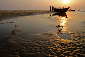
This world is full of so many places to discover, that even a lifetime of travelling will not be sufficient for it. An Indian strange Chandipur beach, located in the Balasore district of Odisha, is a place waiting to be discovered. This is called the Hide and Seek Beach, actually a miracle of nature. Hide and Seek beach always spellbound us by its lovely and unusual creations. Due to its rare and exclusive phenomenon, it is globally popularized as ‘vanishing sea’. Apart from this, there are other amazing features which add to its exceptionality.
One place which is every person would look at through his own perspective, and that's what discovery really means. A phenomenon that is rarely seen in any other part of the world, the sea here recedes by as much as 5KM every day.  Odisha, fondly called the “Soul of India”, is highly rich in its culture and heritage, making it one of the most visited tourist destinations in India. Also, every year in the month of February, a beach festival takes place here to setting folk dance, art, and culture of the State. The beach is also home to biodiversity and supports a wide variety of sea animals.
Well, believe us or not, the beach is not a constantly existing feature on the map. At least it doesn't look the same every time. Is it surprised? Hence, whenever you are at the Chandipur beach, you can actually see the sea disappear in front of your eyes, and come back again and see the area of sand dunes. So, when you are at the beach during the ebb, you can see the water receding massively from the beach and then coming back during the high tide in order to fill up the emptiness. This Hide and Seek of the sea comes to play with you twice a day. However, the locals are fully aware of the time of the high and low tides.
This is the reason why the beach is home to a host of unique species, i.e., horseshoe crab and the red crab. It’s a surreal experience to watch the sea disappear before your eyes and walked on the exposed sea bed. One can find pearls, seashells, crabs and tiny fish on the shore during the times of low tide. This is not something that every other beach offers. The sight of Casuarina trees and sand dunes also call for a visual treat. The ultimate golden colored sea beach has gorgeous casuarina trees and the solitary sand dunes which make the ambiance over there more peaceful and soothing.
However, travelers can visit this dramatic beach anytime. The best time according to the locals is from November to March. Hide and Seek Beach is in depth feel of magic of nature, to feel the wet soft sand under your feet and live up the unforgettable experience. A trip to Hide and Seek Beach will leave you mesmerized on how beautiful and interesting place in India. If you’re visiting beach in the afternoon, then don't miss the spectacular sunset here. Source: CP