Pages

Wednesday, 30 March 2016

The Stone Town of Kuklica, Macedonia


Macedonia is a place with a complicated history similar to many European countries. It has been settled, invaded, conquered, and fought over for thousands of years.  There’s a stone town area comprising of more than 120 naturally formed stone pillars located in the village of Kuklica about 8 km northwest of Kratovo. Kuklica is a small town, housing no more than about 100 inhabitants. However, stone formations are situated on the right bank of Kriva River Valley, an altitude of 415-420 m stretching an area of 0.3 square km. There’s an interesting behind the stone pillars, when there is a man who fell in love with two women but could not decide which he should marry. He was in troubling in dilemma situation between two women. One day he decided to marry both women on the same day at different times.

Therefore, when the first wedding was in progress, the other women saw her future husband marrying another women, she cursed all in attendance at the wedding and turned them into stone pillars. Moreover another interesting story is that, when a popular legend was went in forest in that area, but due to battles it was burned down. After that the area became a wasteland. Even though, the temperatures were very low and when the army passed through the wasteland, all of the soldiers turned into rocks. Furthermore, according to local villagers, new figures appear every five to six years. There’re 4 places at the Balkans where you can this phenomenon, however three of them in Macedonia.

Well, despite the mystic stories the earth pyramid in Kuklica was formed as a result of natural erosion processes in the Holocene, almost 100,000 years ago. The stone dolls of Kuklica, as they’re often called, are recognized in geological circles as earth pyramids, or earth pillars are mainly believed by specialists that they are the product of natural erosion and the more conspiratorial among us roll our eyes on cue. In fact, the entire region was at one time part of a large volcanic system, as most of the rock in the area is tuff (solidified ash) and volcanic rock, both of which are relatively soft.  Thus, differences in the erodibility of the volcanic rocks of the area are the main factor for the pillars creation. Therefore, soft tuffs rocks on the base are overlaid by solid, sturdy andesites and ignimbrites on the top, which are nearly 30 million years old. Kuklica is quite small and not an easy place to find, so it is suggested to hire a tour guide to get the most out of their experience. 

Ancient Acoma Pueblo Sky City

Tiny settlement has been home to the same tribe for 800 years still doesn't have running water or electricity and is reached by a staircase cut out of rock nestled on top of a large cliff in New Mexico is a sleepy commune that is believed to be the oldest continuously inhabited settlement in North America. It is believed that Acoma Pueblo in Valencia County has been occupied by the Acoma people for more than 800 years, since 1150AD - however nowadays it only has 50 full-time inhabitants even they don’t have any running water, electricity or sewage system. In the 1950s part of the rock-face was blown up and a road was constructed to the top. But before that the only way to visit the site via 360 feet above the desert was up a near-vertical staircase carved into the golden rock-face.

Therefore, these days, most visitors use the road, but the staircase is still an option for those who are courageous enough. It is conventional, given its dizzying heights, that the camp is also recognized as Sky City. Several centuries ago, in 1540 Spanish explorer Francisco Vazquez de Coronad was one of the first European visitors to the ancient settlement.  Acoma Pueblo was 'one of the strongest places ever seen, because the city was built on a high rock. The ascent was so difficult that we repented climbing to the top'. Thus, approximately 60 years after this, raids started in the area, led by colonial governor Juan de Oñate. Moreover in a bid to defend their sandstone dwelling, the Acoma Pueblo villagers made the first move and were said to have killed a number of men, including Oñate's nephew.

So, it turned out to be a terrible idea, as two months later the Spaniards pursued revenge, killing 600 inhabitants and enslaving 500 others.  The settlement's population rapidly dropped from 2,000 to just 250, with survivors starts in on the slow process of reconstructing their home. Although, Spanish control was still felt in Acoma Pueblo, though, with villagers enforced to pay taxes on cotton, crops and labour. Furthermore, Catholicism was initiated with the arrival of missionaries and somewhere in between 1629 and 1640 a church was erected in the camp. Building this was no easy feat, as 20,000 tons of stone and earth and 30 foot beams had to be lugged up the steep mountain, because not everyone was pleased with these new changes.

The Pueblo Revolt took place in 1680, with more than 17,000 inhabitants rising up against colonists, wiping out all the Spanish camps in the area. Further invasions occurred during the centuries that followed, mostly from the Apache, Comanche, and Ute tribes and the establishment of railroads in the 1880s saw a stream of missionaries and schools trying to influence the Acoma Pueblo dwellers. Lastly the villagers gave way to a more modern lifestyle, and by 1920 a lot of of the children were sent away to boarding schools for education. Hence, now there are around 300 earthen buildings still unharmed, but very few enduring inhabitants due to the lack of electricity, sewage disposal and running water. The greatest things about Acoma are the people, who consider themselves to be a peaceful and spiritual group that will merged into the world.  

Tuesday, 29 March 2016

Semuc Champey; Guatemala

Semuc Champey, consists of natural 300 m limestone bridge, a natural monument in the department of Alta Verapaz, Guatemala near the Q’echi’ Maya town of Lanquin. The Cahabon River passes under the bridge, and atop of bridge a series of stepped, turquoise pools. Semuc Champey, which in the language of the Maya means “sacred water,” and another name for it might well be heaven. Semuc Champey is a natural wonder tucked away in the mountains of an isolated jungle in Guatemala where the harder rock on the surface has held strong while the river eroded the softer rock beneath.

It’s a famous swimming place among visitors and getting more popular as the time passes. The pools naturally created by Cahabon River which turquoise color and Muddy River runs beneath them and out the bottom of a larger waterfall on the other end. The pools water is so clear, as it is rain water and river may flood over the pools as well. The natural limestone bridge & turquoise blue pools of Semuc Champey had revealed themselves where you can get a great view of the scenery around you. The Cahabòn River water color is incredible a strong bright turquoise blue that sharply stands out from the surrounding green jungle.

So, you should be very careful to get close to the edge, as few people have fallen in here before, never to be found again. Due to this sad incident, the park has hired a guy who stands near the hole and warn you with whistle not go to edges. Make sure to dip into pools, some areas are deep enough to dive into from high points on the limestone shelf. The limestone's have small caves too, and you can swim and enjoy into them and explore from underneath a waterfall. There’s slight sunlight outside reflecting from the bright blue water to give you beautiful view.

This is the perfect place which had inspired visitor’s quest, a source of fascination and trepidation and it looks like Mother Nature’s amusement park. In spite of staggering beauty the place is so cut off but most extraordinary spot you’d have ever seen. A tangle of greenery with lovely parrots in the trees, monkeys, an underground river, miles of stalactite-and-stalagmite-filled caves orchids in the trees, butterflies fluttering: if there was an Eden on earth this might be it.

Monday, 28 March 2016

The Incredible Hydrothermal Fields of Ethiopia

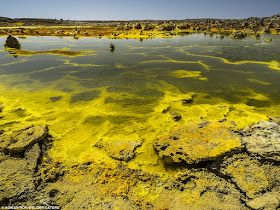
The hydrothermal fields of Ethiopia look like landscape of an alien plant. The amazing photographs of Dallol Volcano in Ethiopia look out of world. Dallol is actually hydrothermal field, is an endless yellow orange landscape, craters stretching for several miles around. The volcano fields are located in the northern Danakil depression. This part of world has too many hot springs which discharge brine and acidic liquid. However almost 150 feet below sea level, Dallol’s craters lowest known subaerial vents in the world, the explosion crater are was formed by the intrusion of basaltic magma in Miocene salt deposits and subsequent hydrothermal activity.
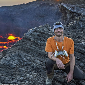
A German based photographer Adrian Rohnfelder, who is curious to look something special in Ethiopia to, fulfilled his desire to shoot active lava lake. He was self-proclaimed lava hunter to shoot lave lake of Erta Ale, another volcano in Ethiopia. Adrian visited this part of world at the end of Feb 2016. He said, I’m really amazed and blown by Dallol, what an incredible view, a massive huge area full of bright colors, like orange, yellow, red, green, blue and white. I was totally stunned and thought this planet is far away on the other side of our milky way, it’s scene I have never seen before.

I took the gorgeous images of lave flowing from volcano Erta Ale, located in the Afar region. Moreover, as well as Dallol's lively landscape alike to the hot springs of Yellowstone Park in the U.S. Therefore, Erta Ale continues Lava Lake has been active from past several decades. I’ve been becoming interested in volcanoes since 2005, the photographing of active lava lake of Erta Ale has long been a dream. Because, volcanoes let me feel the real power of nature in every sense, the ear battering explosions, frightening shockwaves, falling lava bombs and the agonizing heat of nearby floating lava, including the optical spectacle of infinite fireworks. You know, “Erta Ale” volcano with one of the very rare persistent lava lakes on earth of course has been on the top of my volcanic bucket list.

Thursday, 24 March 2016

Taq-e-Kasra The Arch of Ctesiphon


The ancient city of Ctesiphon (Also known Tusbun or Taysafun) on the banks of Tigris, in Baghdad established in the late 120s BC. The city is located about 35 kilometers southeast of modern Baghdad actually one of the great cities of late ancient Mesopotamia and the largest city in the world from 570 AD, until its fall in 637 AD. So during the Muslim conquest the only surviving structure of Ctesiphon these days is the majestic vaulted hall of Taq Kasra, which served as the palace of the Sasanian king Khosrow I, in the late 6th century. The archway is one of the biggest single-span vaults of unreinforced brickwork in the world. The exact time of construction is not known with conviction. However, it is believed that construction possibly started during the reign of Khosrau I after a campaign against the Byzantines in 540 AD.

Mithradates was founded Ctesiphon, “the King of Parthian Empire” as a royal residence, after he annexed Babylonia by defeating the Greeks. Therefore, under the Parthian rule, Ctesiphon became the political and commercial center of the region, and by the end of 58 BC, it had become the Empire’s capital. Progressively, the city was merged with the old Hellenistic capital of Seleucia and other adjacent settlements to form a cosmopolitan metropolis. Moreover, in the 2nd century, the tug-o-war of power between the Romans and the Parthians affected Ctesiphon to change hands between the two Empires for a total of six times. 

Though the obliteration of the palace is blamed on different individuals by numerous sources, Abbasid caliph Al-Mansur (754-775) is most usually mentioned. However, during the last possession, the Romans kick out and looted the city, demolished palaces and carried off thousands of its inhabitants as slaves. Consequently, in 226 AD, the city fell into the hands of the Sasanian Empire, and Ctesiphon prospered once again. The oldest occupied places of Ctesiphon were on its eastern side, which in Arabic sources is named "the Old City", where the residence of the Sasanians, identified as the White Palace, was located. The southern side of Ctesiphon was recognized as Aspanbar, which was acknowledged by its protuberant halls, riches, games, stables, and baths. 

Thus, after another short-lived occupation of the city by the Romans, the Sasanian king Khosrau I recuperated control over Ctesiphon. He then underway building a large palace complex with a large vaulted arch that is 37 meters tall and 26 meters across. The arch top is about one meter thick while the walls at the base are up to seven meters thick. Up to modern times, it was the largest, unverified vault in the world. Besides, after the Arabs took Ctesiphon in 637 AD, they improvised the palace as a mosque until the area was slowly abandoned. Hence, by the end of 8th century, Ctesiphon had been superseded by the lately founded city of Baghdad, and Ctesiphon’s deserted ruins were used as a quarry for building materials. Consequent floods demolished all remaining structures, including Taq Kasra, one third of which was swept away by a flood in 1888.

Henceforth, the striking brick ruin of Taq Kasra is now all that remains above ground of a city that was, for 7 centuries the main capital of the Iranian successor dynasties of the Parthians and Sassanids. In the 1980’s the archway rebuilt process was started by Saddam Hussein's government when the fallen northern wing was moderately rebuilt. Therefore, all works somehow stopped after the 1991 Gulf War. In 2003, before the US-led invasion the area boasted gardens and arbores, as well as a popular museum. In 2004, the Global Heritage Fund said that, as a result of disrepair, the arch was “in danger of collapse”. Taq-e-Kisra was neglected for a long time and decided to rehabilitate it. However, the current Iraqi government is cooperating with the University of Chicago's "Diyala Project" to revive its reputation as a tourism hub has proceeded in fits and starts.