Wednesday 23 May 2018

Graffiti Mesa, Valley of Names, California

During World War II, soldiers training in the desert north of Yuma, Arizona, started decorating a site they called “Graffiti Mesa,” using rocks to write out their names in the white sand. They expressed their feelings by placing stones on a piece of deserted land. They hoped that, even if they may never return home, their loved ones would get to see their message. The different sizes and shapes of rocks have taken many years to take in 10,000 names embedded in the desert floor maintained by the BLM (Bureau of Land Management). The Valley of the Names is covered in beautiful white sand, which creates a strong contrast against the dark-colored rocks. Due to the fact, that the land is barren for miles, each person must bring their rocks from the outlying desert.
The tradition treasure continued on after the war and the graffitied area bigger and bigger. Nowadays over 1,200 acres of land are decorated with signatures, messages, dates, initials, and drawings. The mesa, commonly known as the “Valley of the Names,” located in Winterhaven, Calfornia. It is made up of hard-packed white sand, and the earliest names are arranged using black lava rocks that stand in sharp contrast. It is well preserved land filled area, where you can express your feelings by placing stones on a piece of deserted land. The land is barren for miles around, which means the rocks must be brought in from the outlying desert.
Some people have cheated by bringing bricks and spray-painted rocks from home. If you have a message or name then you require a 4-wheel drive vehicle to access the area. Once there, it’s likely to drive down, around, and through the hills and valleys covered by this exclusive rock art. Hence, you have to bring your own rocks; there are plenty of black rocks on the road leading in. People still leave their distinctive note to loved ones nowadays.
This unique desert has scheduled a clean-up day, when people go out there to clear away debris from the desert winds and replace rocks that might have been washed away in a storm. People are coming here on trips in Trackers, Jeeps or Rangers to fresh their memories which they have written even 20 years ago. Today they use the technology of GPS and record the coordinates so they can remember where it’s at, even find their name without that. Source: CP


Tuesday 22 May 2018

Wai-o-Tapu, Thermal Wonderland


Wai-o-Tapu means “sacred waters”, also spelt Waioyapu is an active geothermal area north of the Reporoa caldera, in New Zealand's. The geothermal area covers 18 square kilometers. Wai-O-Tapu Thermal Wonderland is one of the most surreal places on earth so naturally it’s high on the list of Rotorua’s must-see attractions. The Taupo Volcanic Zone has dramatic geothermal conditions beneath the earth; the area has several hot springs noteworthy for their colorful appearance. This is a place to marvel at nature’s artistic splendor, Wai-O-Tapu Thermal Wonderland is also committed to providing a safe visitor experience.

There are many hot springs, like Lady Knox Geyser, Champagne Pool, Artist's Palette, Primrose Terrace and boiling mud pools. So, by foot, you can view the curated experience naturally forming hot springs appear around the area. Moreover, earlier to European occupation the area was the homeland of the Ngati Whaoa tribe who descended from those on the Arawa waka (canoe). Since 1931, the area has rich history of tourist attraction; well protected the scenic reserve occupies part of the reserve under a concession.
It operates under the name "Wai-O-Tapu Thermal Wonderland crosses Kaingaroa Forest, passes Murupara, and then continues as an unsealed road through the mountains of Te Urewera, along Lake Waikaremoana to Wairoa on the border of Hawke Bay. Wai-O-Tapu mud Pools are completely unforgettable experience was originally the site of a large mud volcano which was destroyed through erosion in the 1920’s. Moreover, the area in which the landscape has been sculptured by geothermal activity and where unique volcanic features can be viewed from well defined tracks.


Friday 11 May 2018

Santa Rosa Blue Hole, New Mexico


On the east of Santa Rosa, there’s bell-shaped pool called Blue Hole located off Route 66 in New Mexico. Like several other natural pools of its similar types, the Santa Rosa Blue Hole is a small body of water that seems to fill a surprisingly deep hole in the ground with shockingly clear waters. The circular blue hole is one of most popular dive destination in the US for SCUBA diving and training session. The arid climes is a natural swimming hole that has a hidden system of underwater caves which were unexplored until 2013. The famous Blue Hole is an artesian well that was once used as a fish hatchery. The blue hole has clear water with a persistent 62 °F temperature and persistent inflow of 3,000 US gallons per minute.

Though the surface is only 80 feet in diameter, it expands to a diameter of 130 feet at the bottom. The site elevation is 4,616 ft, it is necessary for divers to use high-altitude dive tables to compute the dive profile and decompression stops when diving in the Blue Hole. The Santa Rosa deep hole was an ideal spot for scuba divers until two young divers became trapped in the pool’s tight underwater caves. After their deaths in 1976, the entrance to the caves was covered with a metal grate and all but forgotten.

In 2013, a group of adventurous divers were allowed to past the grate with the intention of mapping the system of unexplored caves. Therefore, their early probing was stymied by decades of debris and too tight passages but the excavation continues with a watchful eye towards safety lest further deaths close off the secretive caverns for decades to come. It’s still unclear how far back the caves go. The pool is open for public use with no lifeguards on duty, however another sad incident took place on March 26, 2016 when 43 year old California diver was exploring passageways where he became trapped and drowned.

In fact Santa Rosa Blue hole is a wonderful stop, where divers can jump off the rock or enter via the stairs across from the jumping rock. Santa Rosa is known as the "City of Natural Lakes," is overflowing with pristine bodies of water that provide an invigorating blue splash in an otherwise arid landscape. The Blue Hole, fed from an underwater aquifer, about 8,000 diving permits are issued per year from around the world. A super place particularly in a hot day, as water is cold and refreshing and if you get there earlier in the day before it gets churned up it is crystal clear. It is like a slice of the Caribbean in the middle of New Mexico.


Wednesday 2 May 2018

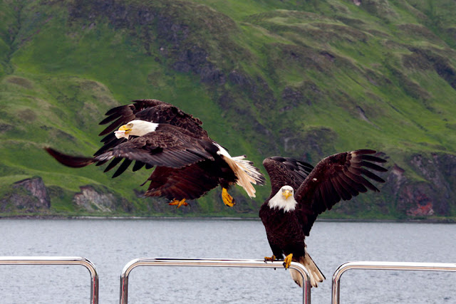
Unalaska, The Town of Violent Bald Eagles


The magnificent bald eagle is the national bird of America, but most Americans are lucky to see one first-hand during their lifetimes. The Unalaska town offers classic examples of the striking nature you'll find throughout Alaska, but seems otherwise unremarkable. Then there's the unnatural amount of eagles here is due to Unalaska simply being a great place for the birds to score food. Unalaska is located on Unalaska Island and neighboring Amaknak Island in the Aleutian Islands off mainland Alaska. The small town of Unalaska, bald eagles are as common as pigeons are in other human settlements. The Unalaska is home of about 5,000 inhabitants, normally spare the space for bald eagles, who lurk above telephone poles, and stop lights watching for potential victims to sweep down upon, litter through trash, and steal grocery bags.

The view looks like out of a fairytale. Bald Eagles naturally built their nest up in trees, but Unalaska doesn’t have too many trees. So, Bald eagles find the other way to build their nests on cliffs, on the edge of town, and in manmade structures. The seven-foot wingspans, flesh-ripping beaks and vice-like talons, eagles rule the island. But why are there annual eagle attacks in Unalaska when raptors and humans peacefully coexist elsewhere in the state?

Therefore, it’s so easy to get a closer look of an eagle nest without even knowing it. The bald eagles get attacked anytime, which is why local law enforcement puts up warning signs all over the nesting season. The nesting season for America’s national bird runs from early June to the end of the summer. When going near their nests, they may be get angry and dislike it. So, local people constantly have a keep an eye out of the birds. There are almost ten cases every year, when people required medical attention after encounters with eagles with lacerated wounds. 

Moreover, fish is the favorite food of bald eagles, so during fishing season myriad eagles comes to scavenge and nest in the fishing town, creating lot of irritation to locals.  When fresh fish isn’t available, the birds will anything with meat, seagulls, ducks, squirrels, mice, the occasional raven, and human leftovers. Despite of all aspects, Unalaska is an excellent place to watch where you can take marvelous photographs. The bald eagles are called Dutch Harbor pigeons by locals. The bald eagles swarm every boat that comes into port, festooning the rigging by the dozen like baleful New Year ornaments.

Source: Charismatic Planet


Friday 27 April 2018

Crystal Mountain, Egypt

With the name of Crystal Mountain, one can imagine of seeing a massive mountain rising up out of the desert. However, the Crystal Mountain is a ridge located between Bahariya Oasis and Farafra Oasis northern of the White Desert, Egypt. The unique structure of ridge is made entirely of calcite crystal that combines altogether to create a striking ridge standing up out of the desert. The hill is a subvolcanic vault, which was emerged during the Oligocene age. The crystals themselves are quartz. The actual name is Crystal Formation, although that is not the common name the ridge is known by. The sun rays make the big rock with its arch to spark even more. The crystal mountain stands on the very edge of the of the White Desert , and soon the black iron and basalt pebbles give way to the sand-blown chalk formations which loom on either side of the road.
The Crystals are perhaps Barite, and Calcite with columnar-shaped stalagmites. The coal seam and hydrothermal impregnated reddish to brownish ferruginous layers, strata are broken or brecciated and intensely with each other folded. The ascertained intense heat of coal seam was transformed to anthracite. Actually Crystal Mountain Egypt is an ancient Paleo that has been pushed to the earth’s surface, and is now in the process of being eroded away by the elements. The Crystal Mountain has almost an oblong or square-like shape. The natural crystal arch, has formed in the ridge, that spring up in the desert all around the mountain. According to the geologists, this structure is a cave made from limestone and completed with stalactites and stalagmites. This cave was shook by the earth movements and the roof was destroyed by erosion while the time passed by. The arch is natural and small and is situated in the center of the structure.
The crystals have increased out of climbed hydrovolcanic solutions. The visible layers are White Desert limestone of the Khoman Fm. Moreover the Barite veins are extensively distributed to the south of Gebel El Hafhuf which is composed of a rock sequence with sandstone, shale, limestone, phosphatic limestone and phosphatic calcareous sandstone. You should never try to break off the crystals on the mountain, as these have been taken thousands  of years to form, and breaking them would be ruining a piece of history. Yes, one can collect pieces of crystal that scatter around the landscape and ridge. Crystal Mountain is one of favorite place of the tourists who want to make pictures here. The Crystal Mountain is an important touristic objective, many of the tourists who come to visit the Farafra Oasis or/and the Baharyia Oasis come to see the Crystal Mountain too.


Wednesday 25 April 2018

Jigokudani Monkey Park, Where Monkeys Bath in Hot Springs


Jigokudani is a valley surrounded by steep rock walls where steam can be seen rising from natural hot springs. Jigokudani Monkey Park, is famous due to massive population of wild Japanese snow monkeys, using natural spa exclusively by themselves. These are also referred to Japanese macaques “Macaca fuscata”, in Yamanouchi, Shimotakai District, Nagano Prefecture, part of the Joshinetsu Kogen National Park, located in the valley of the Yokoyu-River, in the northern part of the prefecture. The name Jigokudani, meaning (Hell's Valley), famous for steam and boiling water that bubbles out of small crevices in the frozen ground, surrounded by steep cliffs and terribly cold and intimidating forests. The heavy snowfalls, covers the area for 4months in a year, an elevation of 850 meters. The main onsen bath was constructed specifically for use by the monkeys.
The Jigokudani Monkey Park is only accessible through a 2KM footpath via forest, mostly uncrowded in spite of being relatively well-known. The monkeys descend from the steep cliffs and forest to sit in the warm waters of hot springs, and return to the security of the forests in the evenings. Though, monkeys are fed by park attendants, they are in the area of the hot springs all the year round, and a visit at any season will enable the tourist to observe hundreds of the macaques. This region receives heavy snowfall usually white from Dec-Mar, with January and February is the best time to visit the monkey park.
During the colder season, when food is very limited available, monkeys congregate in and around the pools for warmth and the daily supply of barley and soybeans. Further, sometimes monkeys are sighted even in the summer as they take occasional baths because they are enticed by food thrown into the pool by park wardens. Moreover, the macaques are medium sized monkeys, have stocky body with both a head and body length of approximately 500mm high. The tail length is less than a quarter of the head and body length, have grayish or brownish fur color, well-developed cheek paunches, ischial callosities and red faces. The biggest male was about 600mm, the biggest female was about 450mm, and infants were about 300mm.
In 1963, a young female monkey clambered into a hot spring to collect soybeans that were floating on the surface of the water. This unusual behavior was followed by others in the troop, and soon it became common for the monkeys to retreat to the hot pools when the harsh winter arrived. Naturally the tourists followed soon after. The wild monkeys keep their own schedules, as there are no fences or cages, and they do whatever they like. That’s the beauty of this whole park, and something that sets it apart from many of Japan’s other animal experiences.
Hence, a visit to the Nagano area would not be complete without seeing the Japan Snow Monkeys. Notwithstanding its relatively remote location, approximately 100,000 visitors trek through the woods of Nagano each year to see wild snow monkeys. Overnight visitors usually base themselves in nearby Kanbayashi Onsen, Shibu Onsen or Yudanaka Onsen. It’s definitely the most scenic, with snow-capped trees backgrounding groups of bathing Japanese macaques. Visitors can observe their natural lifestyle and numerous photos are on display at the park management building.