Sunday 7 February 2016

Grotte de Lascaux: The Famous Prehistoric Cave Printing


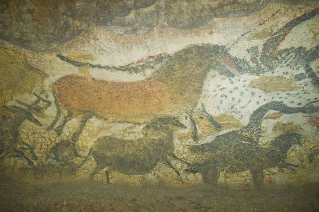
Lascaux is the setting of a complex of caves is the France most famous for its Paleolithic cave paintings.  The cave contains some of best known Upper Paleolithic art. These paintings are believed to be 18000 years old. The paintings primarily comprises of large images of animals. It is thought, these are best known fossil evidence to have lived in this area at that time. Therefore, in 1979 the cave was added to the UNESCO World Heritage Sites list along with other prehistoric sites in the Vézère valley. The figures, which can be grouped into three main categories: animals, human figures, and abstract signs. Lascaux cave has often been referred to well-known for their artistry, more than 2000-strong menagerie of animal images are depicted in Technicolor shades of red, black, yellow and brown, ranging from reindeer, aurochs, mammoths and horses to a monumental 5.5m-long bull, the largest single cave drawing ever found. 

The cave was totally sealed and protected for ages; until 1940 it was discovered by four teenaged boys out searching for their lost dog. It comprises a massive network of chambers well decorated with the most complex prehistoric paintings ever found. In 1948, the original cave was opened for visitors, but within 15 years it became apparent that human breath, temperature changes and introduced elements were causing irrevocable damage, and the cave was closed in 1963. Carbon dating has shown that the paintings are still a mystery why the prehistoric painters consumed so much time and efforts to their creation, and why this specific site seems to have been so significant. Moreover, the most famous section of the cave is “The Great Hall of the Bulls” where bulls, equines, and stags are depicted. 

The Devil’s Elbow, A Forgotten Notorious Double Hairpin Bend


A former stretch of road in Scotland that was so dangerous that it earned the nickname “The Devil’s Elbow” is an attraction for adventurous holidaymakers. The Devil's Elbow, is notorious double-hairpin bend often-quoted gradient of 33 percent is a myth. The modern road bypasses the hairpin bends, but the old road still exists and its route can be walked, or carefully cycled. Though the forgotten historic road overgrown with weeds and slowly disappearing, yet still heavy with the memories of its earlier life.

However, the once be scared double-hairpin bend near Glenshee, Perthshire, Braemar, and Aberdeenshire used to be part of Britain’s highest route, the A93, nonetheless was bypassed when the road was straightened out in the 1960s much to the relief of motorists. However, this road is often blocked by snow in the winter. The beauty of this road still exists, and entices hikers and cyclists, so officials are trying to bring in more tourists with a new rest stop and walking routes. The Devil’s Elbow is located a mile south of the 2,198ft Cairnwell Pass. 

However, once the double hairpin bend was Britain’s most challenging stretch of road, with warning signs push drivers to show “great caution”. In 1967, the Devil’s Elbow gets more famous, when Queen Elizabeth II is being driven to Balmoral by Prince Philip, as crowd’s wave from the roadside.  The British A93 is regularly used by classic car and motorbike fans and increasingly cyclists. Therefore, the newly planned construction will give a new life to this scenic route along eastern side of Cairngorms National Park. The tourists will motivate to get new experience and relish the breath taking landscapes of the Cairngorms. 

Tuesday 2 February 2016

Yungas Road, the Road of Death in Bolivia


The North Yungas Road also known as Grove's Road, Death Road or Road of fate is a road leading from La Paz to Coroico, 56 KM northeast of La Paz in the Yungas region of Bolivia.  In 1995 this is most dangerous road in the world as per American Development Bank Christened, about 200 to 300 travelers killed yearly along the road. The road was built in the 1930s during the Chaco War by Paraguayan prisoners. 

The risky road mention the cross markings on several points where vehicles have fallen. This dangerous route connects the Yungas region of northern Bolivia to the Captial City. This is one of the few routes that connect the Yungas region of northern Bolivia to the capital city. The road has no guard rails; width of single vehicle only 10 feet makes it most scary road in the world. The alongside cliffs up to 2,000 feet, make the horrible condition during rainy season from Nov to Mar. Driver visitiability is hamper during fog and rain and water runoff can turn the road into horrifying muddy track affecting traction. However, in the summer season, rockfalls are common scenario and vehicle dust limits the driver visibility.   

Moreover, the local road rule specifies that the downhill driver never has the right of way and must move to the outer edge of the road. This rule forces the downhill vehicle to stop and give the way to other vehicle. So, in that way passing can be negotiated safely. Therefore, the rest of Bolivia, vehicles are essential to drive on the left side of the road, to give the driver a better view of the vehicle's outside wheel and making passing safer.

The scary road made it more popular destination, enticing more than 25000 thrill seekers every year. However, motor biking enthusiasts made it exclusively favorite road for downhill biking, as 64 KM stretch of continuous downhill riding with only one short uphill section. Therefore, tour operators taking the benefit of it, and catering this activity, providing guide lines, information, transport and equipment. Nevertheless, the “Yungas Road” remains dangerous; about 18 motor cyclists have died on the road since 1998. The Yungas Road has been featured in BBC show “TOP GEAR” & many other TV programs.  However, a Mitsubishi Outlander TV commercial was the first ever filmed on the road.

Therefore, a new alternative route of Yungas Road was updated during the last 20 years or so, included enlarging carriageway from one to two lanes, constructing asphalt pavement, and building a new section between Chusquipata and Yolosa, bypassing to the north one of the most dangerous sections of the old “Death Road”.  This new route features modern construction consists of bridges, drainage, multiple lanes, pavement, guardrails and many other elements that make it significantly safer than the original route. The original “North Yungas Road” is presently much less used by traffic, even though an increasing number of adventure travelers bike it. A fatal accident happens there every couple of weeks, 100-200 people perish there every year. Source: Charismatic Planet

Guoliang Tunnel: The Most Dangerous Tunnel in the World

The Chinese Guoliang Tunnel is amazingly carved along the side of and through a mountain in China. This majestically beautiful tunnel connects the village of Guoliang to the outside through the Taihang Mountains which are located in Huixian, Xinxiang, Henan Province of China. The village name was driven when fugitive rebel during the Han Dynasty, used to fight an overwhelming imperial force to a standstill utilizing the risky local terrain. However, the access to village was extremely difficult on a path craved into the mount side; hence the life gets easy after the construction of Guoliang Tunnel. Therefore, the village is nestled in a valley surrounded by towering mountains cut off from outside civilization. In other words Guoliang was basically cut off from civilization.  The inhabitants were approximately 300 people.  It was unreachable to the outside world until a road was blasted into the cliff side.

Apparently the village is way up on a mountain.  The only way to reach it was to travel through valley surrounded by towering mountains, and then climb the Sky Ladder. The local peoples were in great trouble by transporting different in/out things to outside world. Even communication was another big issue, with no telephones, no electricity. Hence to get the villagers life ease, some villagers decide to find out a solution. In 1972, the group of villagers led by Shen Mingxin plans to carve a road into the side of the mountain.

They were really lack of funds to implement this plan, finally they decide to make a big scarify to sold out their livestock to raise funds to buy material and construction tools.  As the project gets popularity, the nearby villages also involved to start the project with one dying during construction. The peoples were lack of construction facilities, which result in to use the hammers and chisels to make the plan successful. Even though at some certain difficult stage, the tunnel progressed at a rate of one meter every three days. The Guoliang Tunnel is 1.2 KM long, 16 feet tall and 13 feet wide, and it took six years to finish. The tunnel is wide enough to surpass two vehicles easily. The motivations level becomes the project successful. Hence the tunnel was opened for public on Ist May 1977. This massive effort has turned the village into a popular tourist attraction. The area has also been used as a film location.

 Guoliang Tunnel is very distinctive from other road tunnels; because it is quiet, secluded and mysterious, bright in one minute and dim in the next minutes, full of twists and turns. Moreover, tunnel wall is uneven as more than 30 windows of different sizes and shapes. You will see different sizes of windows, some are round and some are square, however the range of dozens of meters long to standard window size. No doubt, the windows are frightening to look down where strange rocks hanging above from sheer cliff. It is not recommended to walk through twisted tunnel is like walking through a labyrinth. You’ll face problem in hearing the sound of vehicles coming from behind. Finally, considering the villagers efforts by using their own technology, the Chinese government will take some steps to make the tunnel safe for future life. Source: Charismatic Planet

Belogradchik Fortress Bulgaria


Belogradchik Fortress is located on the north slopes of the Balkan Mountains, nearby to the northwestern Bulgarian town of Belogradchik.  Belogradchik Fortress is also famous as Kaleto Fortress. The fort is nestled on the base of a remarkable rock formation belonging to the “Belogradchik massif” which comprises of oddly shaped sandstone and conglomerate rock formation that are believed to resemble shapes of objects and people. Therefore, some of the rocks reach up to about 200 meters in height; however the ones serving as the backdrop to the fort are 70 meters tall.

Although this fort existed here since the Roman times. Because in the 1st to the 3rd century AD, the Romans were used to constructed roads across the new provinces of the empire on the Balkan Peninsula, as well as some fortresses to guard them. So, the mission of Belogradchik Fortress was to control the road. At that time they built the highest part of the fortress, famous as the Citadel, using the rocks as natural protection. Moreover fortified walls were built only on the northwest and southeast sides, with the rest of the sides around the yard being surrounded by rocks.

Furthermore, as the time passes with several centuries, Belogradchik Fortress has been used by a succession of not the same forces including the Byzantines. However, in the 14th century, the Bulgarian tsar of Vidin Ivan Stratsimir stretched the old fortress, building fortified garrisons before the existing rock massifs. Thus, fort became one of the most significant strongholds in the region. So, by the end of 14th century, Belogradchik Fortress was take control by the Ottomans, who extended it further and used it to overpower local uprisings. 

Besides, Belogradchik Fortress continued to be used for military and defensive devotions, so until the 19th century. In the mid of 18th century, Belogradchik Fortress played a vital role in the Ottoman suppression of the Belogradchik uprising, being the place where decapitation of captured activists was performed. Therefore, the fort was last used in warfare during the Serbo-Bulgarian War in 1885, so after that the Belogradchik Fortress is now one of the best-preserved strongholds in Bulgaria, and together with the Belogradchik Rocks, it is the town's main cultural and historical sightseer attraction.