The lowering of the flag ceremony was held at Wagah Border in Lahore as a daily military practice which was attended by a large number of people including women, children, old and young on Pakistan Day.
People raised slogans of Allah u Akbar and Pakistan Zindabad as the Pakistan Rangers personnel in their traditional style lowered the flag. The participants’ excitement grew higher as they witnessed the parade ceremony.
Showing posts with label Pakistan. Show all posts
Showing posts with label Pakistan. Show all posts
Tuesday 24 April 2018
Monday 19 March 2018
Race Course or Jilani Park is one of best Park you would ever visit. Here you can see a great manmade waterfall, pouring water from some distance. Peoples love to see this amazing fall with his family and friends. Every day myriad crowds visit this fall, and takes selfies and capture the memorable moments. Here you can some of best shots i took there.
Friday 9 March 2018
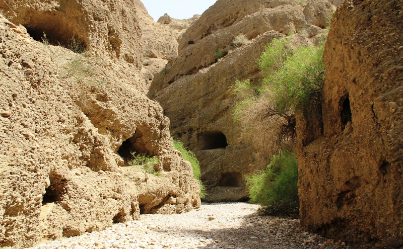
Shehr-e-Roghan, The Mysterious Cave City
In Balochistan, Pakistan there is a famous archaeological town called “Shehr-e-Roghan” referred to the city of caves or city of Jinns. It is known now as Lasbela, located approximately 175 km from Karachi in the province of Balochistan. The wilderness of Balochistan had traces of legends heavily influenced by Persian lore that connects the North and South of Pakistan. This is genuinely a true archaeological treasure but unfortunately this amazing treasure is concealed from the world. Different historians narrate Shehr-e-Roghan also called “Gondrani” with the Buddhists of 7th century AD. This amazing archaic cave city is elongating more than an area of three kilometers. Now what is so unique these cave houses are multi storey and are inter connected with each other through sundry walkways every cave house has a solo room and some have a veranda in front.
Different people have different thoughts, however it is said, that in the time of King of Soloman, a beautiful princess “Badiul Jamal” who was possessed by demons. So many princes tried hard to rescue her but could not successes. One day a prince Saiful Malook came and got rid of her tormentors. He vanquished the demons that haunted the Princess in the Cave city and they both left and went to into the North. Many myths are ascribed to this unexplained place. The locals of Shehr-e-Roghan believe that this might be the city of Jinns. With the passage of time, the caves conditions shaped in poor conditions due to high rate of erosion and lack of conservation efforts from the government. There is a grave of an old woman named Mai Balochani who yielded her life to execute the evil presences and recovery the nearby individuals.
A mystical legend says it was a city of huge Buddhist monastery because 1000 years before Buddhism had flourished in this area. In the British regime, more than 1500 rooms were found, which had ample windows and niches made for what historians believed, were for lamps and hearths in the center of the rooms were also found to keep the inhabitants warm. There were also many pathways within the mountain that connected the rooms together. If government gives some attention, then ancient cave city attracts both local and foreign tourists. The local travelers are looking this amazing site for an interesting expedition to explorer the mysteries.
Therefore, questions still in people minds, that who built these inscrutable caves? Who lived in them? This is still a mystery there is no precise information available but one thing is for sure that this place is extremely marvelous. However, archaeologists and historians thought that the caves have the makings of a Buddhist monastery, probably dating back to the 7th century. So, rumors all over prevails in the recent times, that demons still inhabit the mountains and caves and attack the unwary visitors.


Thursday 19 October 2017
Ansoo Lake, KPK Pakistan
Pakistan is one of those countries,
who are naturally gifted, several mountain ranges, plateaus, deserts, glaciers,
rivers, lakes, and various coastal areas. Ansoo Lake is one of them, which is situated
in Manoor Valley, Kaghan Valley in the Mansehra District of the KPK province of
Pakistan. This lake is considered to be one of the most beautiful lakes of the
world. The name Ansoo means teardrop, comes from its tear like shape, just like
resembles to human eye with a central ice island resembling the iris and a
ridge resembling an eyebrow. Ansoo Lake is considered among one of the highest
lakes of Himalayas, situated near Malika Parbat, the highest mountain of Kaghan
Valley. In the summer, when ice melts, it got more prominent. However, this
beautiful lake was partially destroyed in the 2005 massive earthquake. Ansoo Lake
was discovered by a Pakistan Air Force Pilots who were flying low in this area.
Before that local peoples were not even known about it. As far as stay at Ansoo
Lake, no facilities available here. The tourist use to stay here in camp. The
weather is extremely cold and windy surrounding mountains. It is highly risky
to stay suggested by local peoples.
The Ansoo Lake has two approaches; first one
is short but steeper trek from Saiful Mulook. It takes over 7 to 9 hours round
trip to reach Ansoo Lake. The trek is covered with snow in most parts of the
year. The best time to trek is July till mid-August. The optimal time to set
off for the lake from Saiful Mulook is around 06:00 in the morning, in order to
return before sunset. Horses and guides can also be hired from the Lake Saiful
Mulook. Sometimes, Ansoo Lake is not visible due to dense fog or rain. But you
will enjoy the breathtaking views during trekking. This trek can be separated
into two halves. The first part is through a valley alongside a river to the
base camp of Malika Parbat. The second steeper part is from the base camp of
Malika Parbat to Ansoo Lake.
The Ansoo Lake is located at the
far off deserted and particularly difficult areas; thus, it can become unsafe
if one is not fully equipped and need proper guidance and planning as there are
no lodging facilities available. Therefore, camping is the only available solution,
but it is so windy and ice cold out there that one has to be really prepared to
camp. The second trek to Ansoo Lake begins in a village named Mahandri, located
about 40 kilometers to the south of Naran. So turning left from Mahandri Bazar,
a jeep track leads to Village Manoor. This majestic valley offers attractive
views. Make sure, vehicles cannot proceed further from here. 6 to 7 hours of
trek brings one to a green meadow called “Dher”. From here the trek becomes
steeper. After 3 to 4 hours of trek from Dher at a height of about 16500 feet,
Ansoo Lake becomes visible. There is no risk free way to reach lake waters
because it lies in the crater with steep, snow covered walls. There is no
apparent drainage of lake water and no one ever tried to explore it because of
its dangerous approach and limited resources in that area.


Thursday 14 September 2017
Swaik Lake: Pakistan
Pakistan is a natural tourist’s
destination, and majestic beauty is not only bound to the locations in the
northern areas of the country. But, it is also home to some unexplored gems
like the stunning, mystic “Swaik lake” just waiting to be explored. Swaik Lake
is also called “Khandowa Lake” “کھنڈوعہ جھیل” around 10 km from the Tehsil
Kallar Kahar, Chakwal District and 30 kilometers southwest of Chakwal along the
motorway. It is famous for natural scenes, crystal clear water with tiny
fishes, cliff diving, swimming, and trekking. Swaik Lake is approached with 45
minutes of hiking after the drive of 10 Km by taking an exit from Kallar Kahar
interchange at Lahore-Islamabad Motorway. Swaik Lake is also called “Narumi
Dhan” by local peoples.
It is a beautiful place and very
similar to Neela Wahan pond. The hike to the Swaik Lake is quite similar to the
hike to Neela Wahan although the level of difficulty is a bit higher. In Swaik
Lake, you can enjoy with family, friends and also other activities like Cliff
diving, Treking all along. The lake area consist of variable size filled with
water, localized in a basin, that is surrounded by land, apart from any river
or other outlet that serves to feed or drain the lake. Lakes lie on land and
are not part of the ocean, and therefore are distinct from lagoons, and are
also larger and deeper than ponds. The trail that leads to the breath-taking
beauty is quite wide and narrows down at some parts, and steeply declines
towards the gorge that encapsulates the lake. The lake has become quite a popular place in
recent times, as it’s hard to believe that it’s right here in Pakistan! A
fresh, clear lake is all you can fantasize about on a beautiful day, the lush
green waters just glistening in the broad daylight the cascading waterfall
situated at the lake, you might spot tiny little fish scurrying in the water.


Wednesday 31 May 2017
The Hiran Minar, Sheikhupura Pakistan
The Hiran Minar is one of the best known and most beautiful site
used to be the favorite hunting spot of all Muslim rulers. Hiran Minar or "The Deer Minaret" is 17th
century Mughal-era complex located in the town of Sheikhupura, about 40
kilometers northwest of Lahore in the Pakistani province of Punjab. Hiran Minar
was built at the site of a game reserve in honors of Mughal Emperor Jahangir's
pet antelope, due to his fondness of nature and relationship between human’s
pets and hunting.
Therefore, Hiran Minar was built during the reign of the
Mughal Emperor Jahangir in a hunting reserve used by the Mughal royals. During
the region of Emperor Salim from 1605 to 1627, Sheikhupura had the status of a
royal hunting ground. The minaret itself was built in 1606 as a monument to
Emperor Jahangir's beloved pet antelope, Mansiraj, or "Light of the
Mind". Who had been trained to lure wild animals to the tank in order to
be hunted?
The practice of building such tomb-markers over the skulls of game
animals is an ancient Persian custom. Mughal Emperor Jahangir ordered to build
a tower and a grave for his deer, Mansraj, and he spotted a deer tried to kill,
but accidentally killed his own favorite, Mansraj. The emperor becomes so sad
that he ordered to bury deer in the ground where it died and build a tower
called Hiran Minar. This is a very rare example of love towards a pet, a
gesture of love towards wildlife in a time when the western world was even not
familiar with such intentions.
The reserve was built in a scrub forest, and allowed Jahangir
to get experience of sense of semi-wilderness near the imperial city of Lahore.
The game-reserve was used as a park where visitors could enjoy the sport of
hunting. The minaret and tank were soon accompanied by a larger pavilion, built
during the reign of Shah Jahan. The Jahangir-era minaret stands 30 metres tall,
and was built in 1606 as a tomb marker for the emperor's pet antelope, Minraj.
The sides of the minar are inscribed with a eulogy to the pet antelope. Today after
the collapse of its canopy on the top is 110 feet in height. There are 108
steps on a spiral staircase lead to the summit of the minaret where rest the
remains of Mansraj. A massive rectangular water-tank pool measuring 229 metres
by 273 metres lies at the heart of the complex.
Moreover at the center of each
side of the tank, a brick ramp slopes down to the water, providing access for
wild game that were sought by hunters. An octagonal pavilion built during the
reign of Shah Jahan lies at the center of the pool. The pavilion is
two-storeyed, and topped by a rooftop chhatri that served as a stone gazebo.
The pavilion's architecture is similar to the Sher Mandal at Delhi's Purana
Qila, built by Emperor Humayun. The pavilion was surrounded not only by the
water tank, but also semi-wilderness.
The pavilion was thus likely used for recreational purposes. A
causeway spans the pool to connect the minaret with the pavilion along an axis
which passes through a gateway. Moreove an exclusive features of this specific
complex are the antelope's grave and the distinctive water collection system.
At each corner of the tank is a small, square building and a subsurface water
collection system which supplied the water tank; only one of these water
systems is only extensively exposed nowadays.
This is an enjoyable and calm
place for picnic and to feel relax with gardens in surrounding with a lack and
boating facilities. A thick keekar-jungle flanks the northern side of the pool,
with winding footpaths zigzagging their way over the raised mounds. On the
opposite side the pool a tree-lined garden, with a canteen and some swings and
slides awaits picnickers. The Mughals emperors are famous for their love for
beauty and nature. The Mughals were infatuated with gardens, forts, mosques and
mausoleums, where they lived they erected a structure in any of the above form.
Hiran minar is a different construction from all of Mughal places and a unique
one within its theme and concept.


Friday 26 August 2016
The Lowari Pass, Pakistan
Lowari Pass is also called Lowari
Top is a high mountain pass that connects Chitral with Dir in
Khyber-Pakhtunkhwa, Pakistan. Lowari Top / Lowari Pass is a relatively low
pass, by far the lowest pass to enter Chitral, the others all being 12,000 to
15,000 feet. The Lowari Top crosses the Hindu Raj Mountains, a spur of the
higher Hindu Kush, and on the Chitral side of Lowari Top are the people of
Ashret, whose native is Palula language and were assigned by the Mehtar of
Chitral to be the guardians of Lowari Top.
Although, Lowari Top is shut down
by snow from late November to late May every year. During this difficult time,
jeeps cannot cross so peoples must travel by foot. The local peoples are so
strong and powerful, so they’re habitual of crossing Lowari Top by foot. This
is extremely treacherous, as there are high mountains on each side of Lowari
Top, and a fatal avalanche can come at any moment without warning. Therefore,
in every winter a few individuals are killed by avalanches while crossing
Lowari Top. So, their dead bodies are buried under the snow and it is only happens
when the summer comes and the snow melts that their dead bodies are found and
their fate learned. However, Lowari Top remains one of widespread place because
it is the shortest route from Chitral to Peshawar. Although, the alternative
way would be down the Kunar River to Jalalabad through hostile Afghan Territory
or the much longer route across Shandur Top to Gilgit.
Moreover on the other side which
is called Der reside Khowars, some of whom make their living as porters
carrying loads across Lowari Top. More than 60 years ago, when in 1954, the
Mehtar of Chitral was killed when his airplane crashed into Lowari Top. However,
in these days, even PIA pilots often turn back because of winds and fear of
crossing Lowari Top. The word "Top" is thought not to be the English
word "top" but a word from an ancient language no longer spoken
there. The Lowari Top is one of the four major mountain passes to enter
Chitral. Hence, the others are the Dorah Pass from Badakshan in Afghanistan, Shandur
Top from Gilgit, and Broghol from the Wakhan Corridor in Afghanistan. Furthermore,
in 2009 the Lowari Tunnel was constructed beneath Lowari Pass by a Korean
company. Though, the tunnel was
abandoned presently thereafter and has since fallen into shabbiness.


Saturday 9 July 2016
Karakoram Highway: The Highest Paved International Road in the World
The KKH (Karakoram Highway is one
of the highest paved international road in the world. The road is popular
tourist attraction across Pakistan and China. The KKH connects the Xinjiang
Uyghur, China and Gilgit–Baltistan of Pakistan across the Karakoram mountain
range, located at an elevation of 15,397 feet (4,693 metres). Due to its
extreme elevation and the difficult conditions in which it was constructed, it
is referred to as the Eighth Wonder of the World. It's the road to heaven if
you like exploring the mountains, that is. It's considered as one of the
world's hardest alpine climbs. In Pakistan it is known as KKH while in China it
is known as China National Highway 314. Pakistan and China has strong
friendship relations from last 65 years or so, hence the KKH is also known as
Friendship Highway between two neighboring countries. In 1959, Pakistan and China has made an
agreement to construct KKH, and after so many scarification of Pakistan / China
workers. More than 1000 peoples lost their lives, make the mega project open
for public in 1979. The Karakoram Highway is one of the greatest engineering
accomplishments of the 20th century. Moreover, be ready for heavy snowfalls and
landslides can occur anytime and can sometimes block some sections of the road
for several hours.
KKH is a real challenging road
and a real test of your stamina and vehicle because the road abounds in twists
and turns with wheels sometimes hanging above the precipice. The KKH is highly
land sliding area, trace one of the many paths of the ancient Silk Road,
connecting Gilgit-Baltistan of Kashmir with 1300 KM from Kashgar China, to
Abbottabad of Pakistan. Karakoram Highway has strategic and military importance
to Pakistan and China. The KKH cuts through the collision zone, where China,
Tajikistan, Afghanistan, and Pakistan come within 250 kilometers of each other.
Due to heavy laden vehicles and extreme weather conditions KKH has badly
damaged, however in 2006 Pakistan and China decided to rebuild and upgrade the
KKH. The new proposed width is expanded to 33 to 98 ft, which will increase the
transport three times to its current capacity with a new designed to
accommodate all vehicles and conditions. Moreover, another mega project is
linking with KKH, by planning to connect KKH to Southern port of Gwadar in
Balochistan. This project is named economic corridor of Pakistan / China trade
route and reconstruction and upgrade works on the Pakistani portion of the
Karakoram Highway are underway. China has bigger problems in wanting to use
Gwadar port as an economic corridor, ironically lie more than 2,000 kilometers
away, high in the cloud-tipped Karakoram mountain range in northern Pakistan.
In 2010, a massive 15 km
landslide cut off KKH in Hunza valley; created unstable Attabad Lake, when water
flowing over the landslide dam. The
Attabad Lake reached 22 KM in length and over 100 meters in depth. The massive
landslide destroyed many villages while killing many inhabitants. The subsequent lake completely displaced 20 KM
of KKH including 310 meters of long Bridge on KKH. Therefore, goods transported over the lake by
small vessels to be reloaded onto truck at the other side. So, in 2012 Pakistan
started constructing a revised route around the lake at a higher elevation with
5 new tunnels the longest tunnel is 3360m, followed by 2736m, 435m, 410m and
195m and 2 new bridges. The 24 km long series of bridges and tunnels was
completed in September 15. Therefore, the realignment restored the road link
between Pakistan and China. The highest paved international road on the globe
doesn't come without its dangers.
The KKH total length is 806 KM,
starts from Hassanabdal, of Pakistan section, meets Indus River and continues
along the river till Jaglot, where Gilgit River meets the Indus River. This is
the place, where great mountain ranges meet, The Himalaya, Hindukush, and
Karakoram. The Nanga Parbat, The 9th highest Peak in the world can
be seen from KKH. Moreover, The KKH passes through Gilgit Baltistan and
continues through the valleys of Nagar and Hunza. Thus, some of the highest
mountains and famed glaciers in the Karakoram can be seen in this section. The
highway meets the Pakistani-Chinese border at Khunjerab Pass. The KKH is
exceptionally treacherous and requires a vehicle that can hold its own against
some of the most challenging terrain in the world.
The KKH covers the major towns of
Pakistan, Hassanabdal, Abbottabad, Besham, Chilas, Gilgit, Nagar, Aliabad,
Gulmit, Passu, Sost, Tashkurgan Town, Ghizer, Upal and Kashgar. The terrorist
instability cause becomes a niche adventure tourism destination. Since, 2001
Pakistan is no go area for tourist, tend to only Pakistani and overseas citizen
visit these areas. Those who have been visit these areas are captivate the
beauty of nature and KKH. In 2006, KKH
was ranked third best tourist in Pakistan by the Guardian. The unbelievable
views of K2 along the way make it a popular tourist route; the 800-mile highway
is a nightmare for people who are prone to altitude sickness. With absolutely
no barrier on one side, and shear rock wall on the other, the margin of driver
error is fairly slim.
The KKH has given mountaineers and cyclists
easier access to the many high mountains, glaciers, and lakes in the area.
Karakoram Highway provides the pathway to expeditions for almost all peaks in
Gilgit–Baltistan, Kashmir and several peaks in Xinjiang China. The region
includes some of the world's largest glaciers like the Baltoro Glacier, Nanga
Perhbat and K2. Five of the Eight-thousanders, mountains taller than 8,000 metres
of the world that are in Pakistan are accessible by the highway. The KKH is
best traveled in the spring or early autumn, when heavy snow during severe
winters can shut the highway down for extended periods. Moreover heavy monsoon
rains around July and August cause infrequent landslides that can block the
road for hours or more. The Karakoram Highway is one of the most popular roads
to travel in Pakistan if you're an adventure lover looking for a thrill.


Subscribe to:
Posts (Atom)