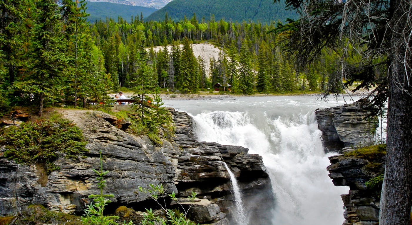
Showing posts with label Canada. Show all posts

Monday 26 January 2015

Athabasca Falls, Jasper National Park in Alberta Canada


Athabasca Falls is a waterfall in Jasper National Park on the upper Athabasca River, approximately 30 kilometers south of the town site of Jasper, Alberta, Canada, and just west of the Ice fields Parkway. An influential, attractive waterfall, because Athabasca Falls is not recognized so much for the height of the falls (23 metres), as it is recognized for its force due to the large quantity of water falling into the gorge. However even on a cold morning, when river levels tend to be at their lowest point, copious amounts of water flow over the falls. The river 'falls' over a layer of hard quartzite and through the softer limestone below carving the short gorge and a number of potholes. 

The falls can be securely watched and snapped from numerous viewing platforms and walking trails around the falls. The rocks near the brink of the falls may look tempting you, but they can be deadly slippery, as many an unlucky soul has realized only too late. So it is highly suggested don't become an Athabasca Falls statistic. Over the years the waterfall has moved back and forth in its search for the path of least resistance, cutting and abandoning channels as it goes. One such channel has been established with stairs and trail for easy exploration. It also gives you to access to viewpoints at the bottom of the main canyon and to the river bank beyond.

Therefore access is from the adjacent parking lot, which leads off Highway 93A just northeast of the falls. Highway 93A takes off from the close Ice fields Parkway, and crosses the falls on the way north to the town of Jasper. White water rafting often starts below the falls to travel downstream on the Athabasca River to Jasper. Athabasca Falls is not the highest or the widest waterfall in the Canadian Rockies but it is the most powerful. Athabasca falls is one of major tourists sight, and extremely busy in midsummer days. If you want to avoid from rush, then you do the visit on early morning, or after dinner time. Hence maximum trail system is well paved but stairs limit access for people in wheelchairs. Without any doubt, this is wonderful picnic spot, with lot of picnic tables, kitchen shelter and washrooms. 

It is a Class five waterfall, with a drop of 80 feet and a width of 60 feet. It is observed that majority of folks who visit Athabasca falls do not give it sufficient time. They just rush to the falls, take a photograph and they’re gone. Why not poke around? Give some more time to explore the zone looking for signs of abandoned waterfalls and other water worn rock. Stand in the spray at the closest viewpoint, or just hang out and enjoy the view.


Tuesday 28 October 2014

Frozen Bubbles beneath the Surface of Abraham Lake in Canada


Abraham Lake is an artificial lake on North Saskatchewan River in western Alberta, Canada. The Lake has a surface area of 53.7 km2 and a length of 32 km. The striking Abraham Lake is home to an unusual phenomenon that needs to be seen to believe. Abraham Lake was created in 1972, with the construction of the Bighorn Dam. Trapped under its frozen surface, methane gas creeps its way up producing lovely air bubbles as it freezes and melts and freezes and melts as the flammable element searches for its way out. The methane is formed when plants & animals in the lake sink to the bottom and react with the bacteria in the water.

The bacteria begin to break down the organic matter, decomposing them, gradually releasing the gas. Generally the gas floats its way to the top of the lake where it is released in the air, but when the lake freezes over, methane skirmishes a little more to find its freedom. Its hardship shapes moving images, leaving admirers breathless. Frozen in the ice are other worldly features, which are so breathtaking and exclusive that they draw photographers from the world over. In the bluish tinged of the winter's ice, photographs capture puffy pedestals of gas, cotton-like bubbles frozen in time and milky stains that color the frozen surface.

Although man-made, the lake has the blue color of other glacial lakes in the Rocky Mountains, which is mainly caused by rock flour as in other glacial lakes. When Abraham Lake is frozen, much older methane from deep beneath the Earth’s crust and ancient oceans remains trapped at the bottom of the lake as a white rock substance recognized as methane hydrate. As the lake beings to warm up, the methane seepages and comes to the surface with combined the methane from decomposition, this generates the amazing-looking frozen lake. The effect is compounded by the fact Abraham is not a natural lake but is the result of the damming of the North Saskatchewan River in northern Alberta in 1972.

The result is extra organic material, such as trees, grasses and plants that would normally not be found on a lake bed, decomposing and creating even more methane gas. As climate change takes its toll in northern lakes and seas, scientists fear that methane that has been frozen by permafrost will slowly start to leak into the atmosphere, pumping out as much as 10 times the amount of methane that is currently in the atmosphere will come out of frozen lakes such as Abraham. This doesn’t just happen in Abraham Lake, either; methane forms in millions of water bodies around the Arctic region as well. Methane is a powerful greenhouse gas that has twenty times the effect on climate change than the similar amount of carbon dioxide over a  hundred years timeframe. Unless, that is, it is burned first.

To demonstrate that the unscented and colorless gas released from the frozen lakes is methane, ecologists from the University of Alaska Fairbanks bravely lit some of the volatile emissions on an Alaskan lake and with some appealing melodramatic results. To do this, the researchers poured warm water onto the ice and then used a digging tool to make a hole, before leaning over the hole with a lighter. The results were quite explosive and like a fire breather performing from beneath the ice. Interestingly emissions of methane are on the upsurge. Ecologist Katey Walter Anthony of the University of Alaska Fairbanks warns, “When we look at how much carbon is in permafrost still frozen and the potential for that permafrost to thaw in the future, we guess that more than 10 times the amount of methane that’s right now in the atmosphere will come out of these lakes.

Although methane seeping from lakes is one thing, it was once believed that permafrost in cold seas was having a lot of the gas trapped yet it appears that this is no longer the case. In a 2010 National Geographic article explained that, the permafrost is actually failing in its ability to preserve this leakage, around eight million tons of methane a year is emitted into the air from the Arctic Ocean’s East Siberia Sea alone, which brings with it the threat of increased global warming.

Friday 24 October 2014

Athabasca Falls Canada


The Athabasca Falls are among the most potent and breathtaking falls in the Rocky Mountains capture the brilliance of rainbow-hued spray or the dazzling sheets of ice suspended from jagged rock on film. Athabasca waterfall is situated in Jasper National Park on the upper Athabasca River, about 30 kilometers south of the town site of Jasper, Alberta, Canada, and just west of the Ice fields Parkway. Athabasca is a powerful waterfall, comprises unbelievable natural scenic beauty, and is not known so much for the height of the falls 23 metres.

The waterfall is recognized for its force due to the huge quantity of water falling into the gorge. Moreover in a cold morning in the fall, the river levels tend to be at their lowest, abundant amounts of water flow over the falls. The huge mountain poised over the falls is Mount Kerkeslin, which was named by Sir James Hector of the Palliser Expedition in 1859. The river falls over a layer of hard quartzite and through the softer limestone below carving the short gorge and a number of potholes. The waterfall can be safely viewed and photographed from several platforms and walking trails around the falls. The approach to fall is from the nearby parking lot, which leads off Highway 93A just northeast of the falls. Highway 93A takes off from the nearby Ice fields Parkway and crosses the falls on the way north to the town of Jasper.

White water rafting often starts below the falls to travel downstream on the Athabasca River to Jasper. Athabasca Falls is actually one of the major tourist attractions along the Ice fields Parkway and is a very busy place on a midsummer’s day. If you want to avoid the crowds it is best to visit early in the morning or after dinner time. Most of the trail system is paved but stairs limit access for people in wheelchairs. There is a perfect picnic area with ten picnic tables, kitchen shelter and washrooms are available and great cross-country skiing in winter.

The falls itself wasn't particularly mind-blowing, but it possessed enough power to carve out a bit of a gorge immediately downstream of it. The huge numbers of peoples visit Athabasca Falls but do not give it adequate time. They rush to the falls; snap a picture and they’re gone. Then why not poke around? This is ideal time to explore the area looking for signs of abandoned waterfalls and other water worn rock. Stand in the spray at the closest viewpoint, or just hang out and enjoy the view.

Wednesday 15 October 2014

Mount Babel Alberta, Canada


Mount Babel is a 10,173 feet (3,101m) mountain peak in the Ten Peaks in Alberta, Canada. As per Peakery data, it ranks as the 140th highest mountain in Alberta and the 258th highest mountain in Canada. The adjacent peaks are Mount Fay, Mount Little, Mount Bowlen, Tower of Babel, Quadra Mountain, and Bident Mountain. Mt. Babel is one of the most popular mountains in the Valley of Ten Peaks that beautifully surrounds Moraine Lake in Banff National Park. The smaller and less known Consolation Lakes lie just behind Mt Babel. 

The stunning lakes can only be reached by climbing across the rockslides that have tumbled down from towering Mt Babel. These images shows the gorgeous beauty of autumn colors of the golden yellow larches on the rocky slopes of Mt Babel and some of them are very big rocks that lie just at the edge of the first Consolation Lake. The dramatic Mount Babel rises vertically some 1000 metres above the Consolation Valley, and the mountain was the scene of one of the most dramatic rescues in the history of the National Park Warden Service. The rout to Mount Babel is really an impressive rock route, because it cannot be called a classic (having only been climbed twice) but it definitely offers a thrilling day's climbing. It could be an astonishing effort for the time when it was first climbed. The majority of the route is now free, with a limited points of aid that keep the grade reasonably sensible. 

Therefore the approach trail (Consolation Lake Trail) to the Tower of Babel is a commonly used trail among the tourists who are delivered in mass by bus to the Lake Moraine Lodge. The one of pictures shown below is actually stitched together from 15 separate images as it is not possible to get this enormous mountain at such close range into a single shot even with a very wide angle lens. The image is taken by standing on a small island in the wide outlet channel from the lake. The gorgeous Mt. Babel can be reached depends upon your fitness level, as you’ve to walked from one rock to another to cross to the island. For the time being, if you look closely you may see tiny companion sniffy stuck on top of a sharp and steep sided boulder middle foreground just at the water's edge. Mount Babel was first climbed by A Hart, Edward Oliver Wheeler, L. Wilson and H. Worsfold in 1910. 

Ten other mountain peaks nearby to Mount Babel 

1.            Mount Fay (3234 m)                         1.1 km
2.            Mount Little (3134 m)                        1.8 km
3.            Mount Bowlen (3206 m)                   1.8 km
4.            Tower of Babel (2221 m)                   2.1 km
5.            Quadra Mountain (3174 m)             2.2 km
6.            Mount Perren (3051 m)                     3.2 km
7.            Mount Allen (Canada) (3310 m)     4.3 km
8.            Mount Tuzo (3248 m)                         4.5 km
9.            Chimney Peak (3002 m)                    4.8 km
10.         Mt Deltaform (3424 m)                       5.4 km